Trails and Rails: Klondike Gold Rush National Historical Park - Amtrak’s Coast Starlight – Train 11 Southbound Between Seattle, Washington and Portland, Oregon
Total Audio Length: loading...
- TEXT: National Park Service Mission Statement
- TEXT: National Park Service Visitors Bill of Rights
- TEXT: Trails & Rails Mission Statement
- TEXT: Opening Announcement — Seattle, Washington, population 724,745
- TEXT: Who Were the Original Northwest Pioneers?
- MAP AND TEXT: Coast Salish / Lushootseed Peoples of Puget Sound
- MAP: Northwest Homeland Tribal Territories
- TEXT: Seattle, Washington: Boeing Field — Mile Post 6.6
- TEXT: Black River
- TEXT: Starfire Sports Complex — Mile Post 9.0
- TEXT: Osceola [oss-ee-OH-la] Mud Flows and Farmlands
- TEXT: Green River Valley or Kent Valley
- TEXT: Manheim Auto Auction
- TEXT: City of Kent, Washington, Population 92,411 — Mile Post 16.1
- TEXT: The Orphan Road
- TEXT: Emerald Downs Thoroughbred Race Track
- TEXT: City of Auburn, Washington, Population 70,180 — Mile Post 21.5
- TEXT: White River and Bridge — Mile Post 24
- TEXT: White River Power Plant
- TEXT: Mount Rainier
- TEXT: Climate Change
- TEXT: History of the National Park Service
- TEXT: City of Sumner, Washington, population 10,900 — Mile Post 29
- TEXT: Puyallup [pyoo-AL-up] Valley Agriculture
- TEXT: Puyallup [pyoo-AL-up] River and Bridge
- TEXT: City of Puyallup [pyoo-AL-up], Washington, population 42,552
- TEXT: The Puyallup Tribe
- IMAGE and TEXT: Chief Leschi [lesh-eye] Schools — Puyallup Tribe
- TEXT: Port of Tacoma — Mile Post 38.3
- TEXT: City of Tacoma, Washington, population 228,200
- TEXT: Freighthouse Square — Mile Post 1.9
- TEXT: Tacoma Dome — Mile Post 2.1 - 2.36
- TEXT: LeMay - America's Car Museum — Mile Post 2 - 2.1
- TEXT: Foss Waterway Bridge — Mile Post 2 - 2.36
- TEXT: Foods of Tacoma Part 1: Candy is an Export of Tacoma
- TEXT: Crossing Over Pacific Avenue — Mile Post 2.3
- TEXT: Nalley Valley: Rail Grade — Mile Post 2.3
- TEXT: Foods of Tacoma Part 2: Nalley Fine Foods — Mile Post 3.59 - 4
- TEXT: Tacoma: A Blue-Collar Town — Mile Post 4
- TEXT: South Tacoma — Mile Post 5
- TEXT: Tacoma Speedway / Pacific Coast Speedway and Tacoma Municipal Airport
- TEXT: Trails & Rails Program Announcement
- TEXT: Lakewood to Nisqually Corridor
- IMAGE and TEXT: Steilacoom Tribe
- TEXT: Lakewood, population 63,612 — Mile Post 8.3 - 14
- TEXT: Fort Steilacoom — Mile Post 8.3
- TEXT: Interstate 5 — Mile Post 10
- TEXT: Joint Base Lewis-McChord — Mile Post 10
- TEXT: JBLM: McChord Field — Mile Post 10
- TEXT: JBLM: Fort Lewis
- TEXT: JBLM: Madigan Army Medical Center — Mile Post 14
- TEXT: Camp Murray — Mile Post 14
- TEXT: Lewis Army Museum — Mile Post 17
- TEXT: Fort Nisqually — Mile Post 18
- TEXT: City of DuPont, population 9,200 — Mile Post 18
- TEXT: Nisqually River Valley / Puget Sound / Olympic Mountains — Mile Post 20.5
- TEXT: South Puget Sound — Mile Post 20.5 - 21.4
- TEXT: Olympic Mountains and Olympic National Park — Mile Post 20.5 - 21.4
- TEXT: Nisqually Indian Tribe
- TEXT: Nisqually River Delta and the Billy Frank, Jr., National Wildlife Refuge — Mile Post 18.5
- TEXT: Medicine Creek Treaty
- TEXT: Pattison Lake
- TEXT: Washington as a State
- TEXT: City of Olympia, population 51, 609
- TEXT: Olympia / Lacey Station — Mile Post 32.2
- TEXT: Mount Rainier
- TEXT: Scotch Broom
- TEXT: Mima Mounds
- TEXT: Travel Then and Now: Kelso to Olympia (1854 vs. 2015)
- TEXT: Solid Waste Trains
- TEXT: City of Tenino, population 1,695 — Mile Post 43.2
- TEXT: City of Bucoda, population 567 — Mile Post 46.7
- TEXT: Lewis County
- TEXT: City of Centralia, population 16,336 — Mile Post 54.4
- TEXT: City of Chehalis, population 7,533 — Mile Post 57.7
- TEXT: Mount St. Helens
- TEXT: Introduction to Napavine, Winlock, and Vader
- TEXT: Land of Big Trees and Big Logging
- TEXT: How did we get here?
- TEXT: Napavine and Napavine Hill, population 1,893 — Mile Post 65
- TEXT: City of Winlock, population 1,314 — Mile Post 73.3
- TEXT: Every Kid Outdoors
- TEXT: City of Vader, population 614 — Mile Post 77.2
- TEXT: Cowlitz River and the Cowlitz Native Americans — Mile Post 83.8
- TEXT: Toutle River and Bridge
- TEXT: City of Ostrander — Mile Post 93.4
- TEXT: Weyerhaeuser Woods Railroad Bridge / Rocky Point Trestle
- TEXT: Cities of Kelso, population 12,130 / and Longview, population 37,602 — Mile Post 97.3
- TEXT: Golf Course South of Kelso-Longview
- TEXT: Columbia River — Longview Junction
- TEXT: City of Kalama [Kaa-Lama], population 2,312 — Mile Post 107.5
- TEXT: Lewis and Clark Country
- TEXT: Columbia River Wildlife
- TEXT: Steelscape Rolling Mill
- TEXT: Emerald Kalama Chemical
- TEXT: Kalama Export Grain Elevator
- TEXT: RSG Forest Products
- TEXT: Kalama Totem Poles
- TEXT: TEMCO Export Grain Elevator
- TEXT: Railway at Kalama
- TEXT: Columbia River History
- TEXT: Columbia River Characteristics
- TEXT: City of Woodland and Mount Adams
- TEXT: City of Woodland and Hulda Klager Lilac Gardens — Mile Post 118.3
- TEXT: Lewis River and the Ridgefield National Wildlife Refuge / Cathlapotle Plankhouse
- TEXT: Cathlapotle [CATH-la-pottle] Village Site
- TEXT: Lewis and Clark Slept Here
- TEXT: City of Ridgefield, population 4,763
- TEXT: The Ridgefield School District has Unique Mascot Names
- TEXT: D.B. Cooper
- TEXT: City of Vancouver, population 175,673 — Mile Post 136.5
- TEXT: Crossing the Columbia: Two Bridges
- TEXT: Mount Hood
- TEXT: Vanport, Oregon — Mile Post 9.0
- TEXT: City of Portland, Oregon, population 647,805
- TEXT: Willamette River [will-AM-et]
- TEXT: Portland Business Woman, Gert Boyle (One Tough Mother)
- TEXT: St. Johns Bridge
- TEXT: Willamette River Valley / Glacial Lake Missoula
- TEXT: Portland's Union Station — Mile Post 0.0
- TEXT: National Park Sites In and Around Oregon
“To conserve the scenery and the natural and historic objects and the wildlife therein, and to provide for the enjoyment of the same in such manner and by such means as will leave them unimpaired for the enjoyment of future generations.”
↑ back to top
“To have their privacy and independence respected; To retain and express their own values; To be treated with courtesy and consideration; and To receive accurate and balanced information.”
↑ back to top
“To Enable Amtrak to enhance the overall experience of passengers by offering interpretive programs that educate them about the natural, cultural and historic content of the world they view outside the train, while also creating an awareness of and respect for America’s ‘special’ places within the National Park System.”
↑ back to top
TEXT: Hello, ladies and gentlemen. My name is C-More, from Access Hound, LLC, an automated agent here to help guide you on this trip.
In this role, I am your National Park Service Interpretive Guide, and I’ll be commenting on points of interest along our route from Seattle to Portland.
I am a volunteer with the Trails & Rails Program of Amtrak and the National Park Service, based out of the Klondike Gold Rush National Historical Park in Seattle.
Please join me in the upper level of the Lounge Car, which is located behind the Dining Car and in front of the Coach Cars. It’s the car where the windows stretch nearly from the floor to the ceiling. Think of this train as your rolling National Park.
As part of today’s journey, the Coast Starlight will travel through rich farmlands and forests, by historical landmarks, and alongside and cross over the mighty Columbia River. Weather permitting, we hope to enjoy some good views of the Cascade and Olympic Mountains.
I’m happy to share a little insight into the Pacific Northwest. Again, you’re invited to join me in the upper level of the Lounge Car anywhere between now and Portland for this National Park Service Program.
↑ back to top
TEXT: Raise your hand if you reside in the Pacific Northwest? For those from Washington State or Oregon, did you move out here by yourself from a different part of the country or, perhaps, another part of the world? Did your parents, grandparents or other family members move to this region first? Perhaps a handful of us had families that go back several generations who traveled to the Pacific Northwest attempting to find a better place to live, work, and raise their family.
Before any of us or our ancestors stepped foot here, Native Americans lived in the Pacific Northwest for upwards of 10,000 years. Between Seattle and Portland, we’ll travel through the ancestral home of the Duwamish, Puyallup, Nisqually, Chehalis, Cowlitz, Cathlamet, Multnomah, and Clackamas Tribes (or Nations).
Isn’t it kind of odd how history often refers to the first Euro-Americans who explored or settled in the Pacific Northwest as pioneers, yet this area had been home to Native Americans for thousands of years?
How do you think the Native Americans felt about the Europeans and Americans who traveled into and settled on the ancestral lands of the Pacific Northwest’s indigenous residents?
↑ back to top
DESCRIBING: A vertical color map of the Puget Sound in Washington state.
DESCRIPTION: No description provided.
RELATED TEXT: The interior fjord that maps mark as “Puget Sound” has long been called “Whulge” (meaning salt water) by Native people. Today, we will travel through the ancestral lands of several tribes or Indian nations, including the Suquamish, Duwamish, Muckleshoot, Puyallup, Steilacoom, Nisqually, and Chehalis. They are broadly grouped as Southern Coast Salish people, for their languages, which are part of the Coast Salish group. In Puget Sound, the principal Native language is Lushootseed, with other languages such as Twana, Upper Chehalis, and Cowlitz.
Annually, indigenous people moved throughout their territory setting up temporary camps to harvest the abundant food resources. They traveled along the shorelines of Puget Sound, on its rivers, through its prairies, forests, and mountain slopes which offered access to foods they harvested seasonally, including salmon, trout, herring, clams, deer, elk, ducks, camas, berries, and other greens.
Cedar trees would be carved into canoes for transportation or cut into planks for houses. When you think of Native dwellings, do you typically picture tipis? That’s the Plains Indians. Northwest Indian peoples were known for their longhouses (one of which we hope to see today near the Columbia River). Housing several families, these structures could reach 500 feet in length. A contemporary analogy might be a co-op apartment.
↑ back to top
DESCRIBING: A horizontal color map of the land in the United States that includes Washington, Oregon, Idaho, and part of Montana.
DESCRIPTION: No description provided.
Caption: Map of the Northwest Homeland Tribal Territories [excluding most of the western half of Montana].
↑ back to top
TEXT: Boeing Field, also known as King County International Airport, is one of the busiest general aviation airports in the country.
The airport was built in the 1920s [1928]. Today, Boeing Field serves small commercial passenger airlines, cargo carriers, private aircraft owners, helicopters, corporate jets, military, and other aircraft. It is also home to the Boeing Company’s testing and delivery facility. If you’ve flown to or from Seattle, you’re much more likely to have traveled through SeaTac International Airport about six miles to the south.
Boeing Field has two runways, one 10,000 feet long for jets, and less than half that length [3,700 feet long] for general aviation. More than 200,000 take-offs and landings occur here each year (that’s over 500 a day).
When the President of the United States flies to the Seattle area, it’s not uncommon for Air Force One to land at Boeing Field. [the Secret Service rotates flying in and out of SeaTac and Boeing Field].
↑ back to top
TEXT: Baker Rendering Plant — Mile Post 8.7
TEXT: Notice the small industrial plant that looks like an oil refinery. This is the Baker Commodities rendering plant, the first Point of Interest in one of our themes today: Recycling. Did you ever wonder what happens to animals who have finished their natural life spans on a farm, the grease from grease traps in restaurants, or leftovers from butchering to banquets? Much of this animal waste ends up at rendering plants such as this to be turned into useful products: biodiesel, livestock feed, and even cosmetics.
↑ back to top
TEXT: Seattle, Washington: The Boeing Company
TEXT: Founded nearby during World War I [1916], the Boeing Company is one of the world’s leading aerospace companies. Principally, Boeing has manufactured aircraft, spacecraft, and their components for use by commercial airlines, air forces around the world, and for NASA.
Have you ever flown commercially on a Boeing jet? If so, there’s a good chance it was built in the Greater Seattle area. Today, Boeing’s local, major commercial production facilities are located in Renton, Washington, about five miles to our east-southeast (it manufactures the Boeing 7378), and in Everett, Washington, a little more than 25 miles to our north [it manufactures the Boeing 747, 767, and 7779 [since 2021, the 787 Dreamliner is manufactured exclusively in North Charleston, South Carolina]. The aerospace industry in Washington accounts for about 13% of the state’s economy.
Located near Boeing Field, the first Boeing factory manufactured seaplanes about the time of World War I.
During the Second World War, Boeing built thousands of heavy bombers (B-17 Flying Fortresses at Boeing Field and B-29 Superfortresses at nearby Renton).
There was a real fear at the time that the Japanese might attack the Boeing facility. To hide the bomber-manufacturing center from enemy aircraft, “burlap houses and chicken-wire lawns camouflaged the rooftops” of the B-17 plant so that, from the air, it resembled a quiet suburb.
Boeing test planes are often seen on the north end of Boeing Field – look for “737,” “747” or “787” on the tails. Boeing is one company that pioneered hiring women in fact, from its founding in 1916. By the end of World War I [1918], the workforce was 25% female.
During World War II, Boeing manufactured thousands of bomber aircraft in the Seattle area, including the B-17 Flying Fortresses and B-29 Superfortresses. With so many men in uniform, Boeing’s employees rose to over 40% female.18 Can you picture a poster or photo of “Rosie the Riveter” building aircraft? Thousands of “Rosies” women joined the wartime workforce, toiling around the clock in Seattle for Boeing and in California for the Douglas Aircraft Company.
Diana Rhea, Boeing’s first female manager in manufacturing engineering, held the employee longevity record at Boeing: 75 years of uninterrupted company service. She retired at age 95 with 75 years of service in March of 2017. [She passed away in 2018 at age 96.]
↑ back to top
TEXT: Duwamish River and Duwamish Tribe — Mile Post 8.0
According to author B J Cummings, “[t]he city of Seattle was born from the banks of the Duwamish River.” The Duwamish is the only river that cuts through the city, flowing northwestward into Elliott Bay. It rises in the Cascades as the Green River – which we’ll soon travel alongside. The Green-Duwamish is one of five major watersheds we’ll cross. Where once mature forests lined its meandering shores, today its path has been straightened and channeled, its banks highly industrialized, its waters contaminated. But it’s now undergoing clean-up and restoration.
The Duwamish takes its name from the Duwamish people who have lived along its banks for centuries. The Duwamish Tribe is one of the Lushootseed-speaking Coast Salish bands whose traditional lands ring the Puget Sound watershed. The Duwamish refer to themselves as the “People of the Inside.”
Chief Si’ahl/Chief Sealth/Chief Seattle: Boy Grows into a Leader
Navy’s HMS Discovery, was conducting the first recorded exploration of the Puget Sound area by Shortly after the Revolutionary War [1792], a Native American boy named Si’ahl stood with his father on the shores of Puget Sound and watched as a giant ship resplendent with guns, steel and other goods anchored offshore. Captain George Vancouver’s small squadron, led by the British Europeans, the prelude to the eventual invasion of outsider settlers.
Si’ahl would grow up to be a warrior, orator, and diplomat. In fact, he became chief of the Suquamish and Duwamish Tribes and a leader of a six-tribe confederation of Central Puget Sound. He continued friendly relations with the Euro-Americans who explored and settled in this area over the course of his lifetime.
Chief Si’ahl/Chief Sealth/Chief Seattle: Town along the Duwamish River
By the 1850s, Euro-Americans began settling along the shores of the Duwamish River. Chief Si’ahl encouraged these new inhabitants to build a trading post. David “Doc” Maynard would open a successful general store along the Duwamish and Chief Si’ahl became one of his best customers and good friends. Thus, the town called Duwamps was born, named for the Duwamish Tribe.
Would you be grateful or upset if someone named a town after you? Doc Maynard suggested the town fathers change the name to Seattle to honor his Native American friend. By Anglicizing [to make English] the name Si’ahl, you get Sealth or what most of us know as Seattle. Thus, Chief Si’ahl is best known by the English pronunciation of his name – Chief Seattle.
Ironically, Si’ahl hated the idea of the town bearing his name. Tradition taught that after he died, “his spirit would be disturbed whenever his name was spoken.” Despite not wanting the town to bear his name, his protests failed. When he died, he was buried across Puget Sound near the town of Suquamish. “Hopefully, he is far enough away from the city that bears his name so that his spirit is not disturbed whenever the name ‘Seattle’ is mentioned.”
Chief Si’ahl/Chief Sealth/Chief Seattle: Sacred Lands
Chief Si’ahl was a gifted speaker and (like many Native Americans) could be called an early environmentalist with his respect for place. In 1854, he was recorded as saying “Every part of this soil is sacred in the estimation of my people. Every hillside, every valley, every plain and grove, has been hallowed by some sad or happy event in days long vanished.”
Chief Si’ahl/Chief Sealth/Chief Seattle: Supporter of the new “Immigrants”
Have you ever considered that the white settlers who came to the Pacific Northwest were “immigrants” and that established Native Americans lived on these lands before them?
Chief Si'ahl / (Seattle) was a member of the Duwamish and Suquamish peoples who lived near current-day Seattle. Like most Salish groups, they did not live at one site all year, but were moved according to seasons and food sources.
When settlers began arriving at Elliott Bay, Seattle had become well-respected for his peaceful ways rather than the war prowess of his younger life. He cordially greeted the first Euro-American settlers when they arrived nearby. In fact, he had invited them! He acted as both a protector and benefactor to the new “immigrants”.
Seattle and his tribes were very helpful to the settlers in times of distress. Without Seattle’s leadership and his peoples’ generosity during their first winter, the newly arrived settlers’ lives would have been grim indeed. The Duwamish Tribe provided local guides and valuable canoes for transportation. They also shared their skills and knowledge, which enabled the settlers to not only survive but thrive. For example, they provided local food such as salmon, venison, shellfish and a kind of potato called wapato (“WAH-puh-toe”). The Duwamish also taught them how to make a traditional plank house from cedar trees (without a lumber mill). Most notably, when there were no cows to provide milk to the settlers’ hungry children, the women taught the “immigrants” how clam juice could be a substitute.
Eventually, the new town was renamed in honor of Chief Si’ahl (Sealth) with the anglicized, alternative pronunciation of “Seattle.” He is still remembered for these wise words:
“This we know; The earth does not belong to man; man belongs to the earth. This we know, all things are connected like the blood which unites one family.”
The Foster Golf Links was established in the 1920s [1925], and is a public course owned by the city of Tukwila.
↑ back to top
TEXT: Seattle, Washington: Museum of Flight
TEXT: Located near the southwest end of Boeing Field is the Museum of Flight, one of the largest air and space museums in the world. The Museum’s collection includes more than 160 historically significant airplanes and spacecraft, from the first fighter plane (1914) to today’s 787 Dreamliner. Nearly three-quarters of a million guests and researchers visit the Museum of Flight annually. It’s also home to the world’s only full-scale NASA Space Shuttle Trainer which was used by every astronaut who flew on the Space Shuttle – and visitors can enter and stand in the cargo bay. In view in front of the main building, is a Lockheed Super Constellation [1049G], a B-47 Stratojet, and a B-29 Superfortress. The B-47 was the country’s first swept-wing multi-engine bomber in 1951, and every large jet aircraft today is a descendant of the B-47.
Beyond the Museum of Flight’s main building is a covered airpark showcasing a 707 used as Air Force One, a retired British Airways Concorde, one of the first three Boeing 787 wide body jets – the carbon-fiber Dreamliner, and a B-52 bomber serving as a Vietnam War memorial.
↑ back to top
TEXT: This is what’s left of the Black River. Lake Washington once drained via the Black into the Duwamish and out to the Sound. This is one more example of how so much of our original landscape – both waterways and landforms – has been altered by human engineering. When a canal was dug in the early 20th century, allowing ships to pass from Lake Washington directly to Puget Sound, it lowered the lake level and left the Black River high and dry. As local historian Jennifer Ott has remarked, and we will often observe: “This land can only be known by knowing how changeable it is.”
↑ back to top
Do you remember playing soccer as a kid, be it with friends, at school, or perhaps in a local league? Did you ever practice or play on fields quite like the ones on our right?
Here in Tukwila, the campus of Starfire Sports features over 15 soccer fields (a couple of pitches are even indoors). The mission is to make soccer inclusive “with access to world-class facilities: a place where everyone in the community could participate, regardless of race, religion, social background or ability level.” Starfire Sports is surrounded by some of the poorest communities in King County and is able to draw in kids living well below the poverty line to provide them with sports opportunities that aren’t typically available.
Starfire Sports offers venues for all ages. Both amateur and professional teams train and play at this complex. The Seattle Reign, the area’s professional women’s soccer franchise, practices here. Starfire Sports is also the administrative headquarters and official home training facility of the Seattle Reign. The Seattle Seawolves, the Professional Rugby Club, now also plays there.
[Until 2023, the Seattle Sounders FC practiced at Starfire, but they recently moved to Sounders FC Center at Longacres in Renton.]
↑ back to top
TEXT: The rich farmland of the Green River Valley (also known as the Kent Valley after its largest city) derived from a surprising source. This valley was once underwater – part of Puget Sound – until about 5,600 years ago, when Mount Rainier lost 2,000 feet off its top in a major eruption. A giant landslide, called a lahar, flowed off Mount Rainier. Geologist David Williams describes a lahar as a massive rock avalanche triggered when magma melts glacial ice, forming “a concrete-like slurry” that bulldozes downward, “leaving behind a blanket of death, desolation, and destruction.” This lahar, known as the Osceola Mud Flow, rocketed off the volcano’s slopes, at times reaching speeds of more than 130 miles per hour. The flow followed the White River from the top of Mount Rainier around the northwest side of the mountain into the Green River at Auburn.
Hot debris-filled mud inundated the valley, extending land into Puget Sound 30 miles farther than before the eruption. Osceola deposits cover an area over 200 square miles [212 square miles or about 550 square kilometers] in the Puget Sound lowland, extending at least as far north as the city of Kent, and to the southwest at Commencement Bay, now the site of the Port of Tacoma. The communities of Orting, Buckley, Sumner, Puyallup, Enumclaw and Auburn are also wholly or partly located on top of Osceola deposits. More recent lahars, like the “Electron Mudflow” just 500 years ago (1507), eventually extended the Duwamish River valley to its present location at Elliott Bay.
The rich land provided nutrients for native plants such as salal [sah-LAL], salmonberry, blackberries and huckleberries, nuts, and roots of the camas [CA-muss] and potato-like wapato [WAH-puh-toe]. All these were harvested by generations of local tribes [see more under Puyallup]. The early Euro-American settlers in the area farmed between here and north to present-day Seattle. Today’s crops include potatoes, cucumbers, lettuce, cabbage, squash, pumpkin, berries, and rhubarb.
↑ back to top
TEXT: This area is known as the Green River Valley, after the river which flows through it and becomes the Duwamish in its lower stretch. Early Euro-American settlers farmed throughout these lowlands. It was first settled in the mid-19th century, as people took advantage of the Oregon Donation Land Claim Act of 1850. This early version of the more famous Homestead Act granted 320 acres of free land to any person who would live on their claim for four years and make productive use of it. Wives could be granted an additional 320 acres in their own name. It was astonishing for women to own land at the time. (An acre is about the size of a football field; 640 acres is precisely one square mile.)
Over 7,400 land grants were made between 1850 and 1855. Euro-American settlers found that a variety of produce—lettuce, cabbage, potatoes, hops and berries—flourished in the rich soil. Although much of the land is now residential and industrial, local farmers continue to grow crops in this region. Many of the farmers now truck their produce to sell in Seattle and at many local farmers’ markets.
↑ back to top
TEXT: We are all familiar with the recycling of automobiles. The Manheim Auto Auctions,[and other similar businesses], are in most cities around the country to facilitate this recycling. An auto dealer will bring trade-ins that they do not need on their used car lots to auctions like this. At the same time, they often buy at the auction other makes and models that they do need. Manheim facilitates the recycling of some 8,000,000 autos per year nationwide.
↑ back to top
TEXT: We are passing through the city of Kent, Washington, first called Titusville. Have you ever purchased any Carnation products at your grocery store? The Carnation Milk Company started here in 1899, manufacturing condensed milk from famously “contented cows” improved through shrewd breeding. Carnation Farms has recently been reborn as a “community-based hub for regenerative food and agriculture.”
Even earlier [1880s], hops were the major source of Kent's economy, especially after an aphid invasion that affected hops crops in Europe. What are hops used for? That’s right, it’s a key ingredient in beer. In 1888, about one million pounds of hops were harvested here – fully three-quarters of the nation’s hops harvest. Production was so important that the town was re-named for Kent County, the top hops-producing region in England. But then Western Washington got its own invasion of those darn aphids in 1891, effectively ending its hops reign. Yet Washington State remains the nation’s top hops producer, though now it’s all grown in Eastern Washington.
Would you believe the world’s most expensive car was manufactured here in Kent? It was much more expensive than the modern Bugatti Chiron hyper sports car. The electric vehicle built here lacked windows, doors, a hood, a trunk, rear seats, windshield wipers, a stereo system, a heater, and even turn signals. How would you like to travel in a car that had less than four horsepower?
Only about four of the vehicles were ever made, at a cost of just under $10 million each [the program cost was $38,000,000]. What’s more, only three of the vehicles ever were driven, the car’s top speed was about 8 mph and the farthest it ever traveled was around 12 miles. But at least it included an antenna dish, could be folded up, and weighed less than 500 lbs.
Can you guess why it was so expensive but lacked the power and features of a modern car? I’m actually describing the lunar rover, built by the Boeing Company for NASA in the early-1970s for its Apollo 15-18 Programs. It was also known as the “moon buggy,” because it resembled a dune buggy that astronauts could drive on the moon. In addition to two astronauts, the vehicle carried tools, scientific equipment, and lunar samples.
The lunar rovers led to several “spin-off” products for civilian and military use, including robotic vehicles and advanced motorized wheelchairs. The multi-purpose “joystick” that controlled the rover was later adapted for computer games. A variation was developed to enable those without use of their legs to drive.
NOTE: [$10,000,000 each was in 1971 U.S. dollars, thus the cost per vehicle in 2019 U.S. dollars is closer to $76,000,000 [$76,152,345.68].60 [For comparison purposes, one of the world’s fastest production cars, the Bugatti Chiron Super Pur Sport costs around $3.6 million and has a top speed in excess of 200 mph [217 mph]. Unlike the lunar rover, this hyper sports car is more likely to feature windows, doors, a hood, windshield wipers, a stereo system, a heater, A/C, and even turn signals. It also has in excess of 1,600 horsepower.]
↑ back to top
TEXT: This rail line through the Kent/Green River Valley has a colorful history. The earliest transcontinental, the Northern Pacific Railroad, reached Tacoma from the south in 1883. Seattle remained connected to the outside world solely by water. Trains finally pushed on from Tacoma to Seattle in the mid-1880s[1884], but service was poor, and there was no way to turn the engine around in Seattle, so the train had to back up to return to Tacoma. The line lasted just one month.
Seattle howled with outrage, Tacoma gloated, and the track became known as the "Orphan Road.” Finally, the farmers and tradespeople in the valley got fed up. In September 1885, they convened a town meeting in Kent to demand that the trains be restored at once or they would lobby Congress to revoke the railroad’s land grant status [for every mile of track laid, land grant rail roads received approximately 6,400 acres of land in return]. Service resumed, improvements were made to the line and the schedule, and we get to travel that same route today.
Here at the south end of Kent the tracks cross the Green River.
↑ back to top
TEXT: Emerald Downs, Western Washington State’s only thoroughbred racetrack. Before reaching the grandstand area we may get to see the horses being exercised on circular “Hot Walkers” at their barns. Racing takes place from May to September. We sometimes see horses on the main track but you need to watch closely through the fence.
↑ back to top
TEXT: Have you ever known a person to change their name? What about a city or town? New Amsterdam changed its name to New York City; Constantinople is now known as Istanbul; and Leningrad is once again St. Petersburg. The city we’re traveling through also changed its name and I bet you’ll appreciate the reason behind it.
White settlers first established farms in this area in the 1850s. Many of the local Native people had welcomed the newcomers as good trading partners, but when Isaac Stevens, the first territorial governor, tried to push local tribes onto small reservations, some resisted relocation and a war broke out in 1855. U.S. Army Lieutenant William A. Slaughter lost his life in the skirmishing. Thirty years later, when a town was organized, it was incorporated as the Town of Slaughter, a memorial to the Lieutenant.
Are you familiar with the phrase “People are always meaning well … That’s often the trouble?” In the 1890s, a hotel was referred to as a “house” and often included the name of the town. So of course buggy drivers from the local hotel were in the habit of greeting trains by calling out "this way to the Slaughter House!" It took just two years for the town’s name to be changed from Slaughter to Auburn by popular demand.
The new name is taken from an Oliver Goldsmith poem [“The Deserted Village”] which begins “Sweet Auburn, the loveliest village of the plain…”
The early 20th century was a time of very rapid change for the small farming town of Auburn. In the late 1880s [1888], the Northern Pacific had opened its Stampede Pass route over the Cascade Mountains directly into Auburn. Beginning in 1910, the Railroad built the large freight yards and maintenance facilities on the Left Side. The town entered the industrial age and grew quickly.
Shortly before the U.S. entered World War II [1941], the United States War Department feared a conflict with Japan. Needing warehousing with transcontinental rail and ocean port access, they built the warehouse complex you now see on our right.
Part of the complex has been sold to private industry, but the General Services Administration
[GSA] now operates the warehouses for use by federal and state agencies. Part of the National Archives is stored here.
↑ back to top
TEXT: The White River is the first of four major rivers which flow from the glaciers on Mount Rainier. It used to merge with the Green to become the Duwamish, emptying into Puget Sound at Seattle’s Elliott Bay. During the Great Flood of 1906, the Kent Valley turned into a giant lake; that natural disaster, abetted by human manipulation, carved a new channel, diverting the White River into the Puyallup River. As a result, the White River now flows about 30 miles farther south than before. Since the late-1940s [1948], two dams have been built to control the flooding. Does the water appear cloudy? That’s due to silt and ‘glacial flour’ [ground up rock] from its glacial source on Mount Rainier.
↑ back to top
TEXT: The Pacific Northwest has long boasted of its clean energy in the form of hydropower. Here’s an early example. The White River Power Plant opened in 1911. Its generators were turned by water that flowed from Lake Tapps, one mile east and uphill of here. They provided hydroelectric power for the Tacoma area. After more than 93 years of continuous service, the plant was de-commissioned in 2004, when mechanical improvements to the plant were considered too expensive. What do you think about the tradeoff between clean hydro energy and the dams that interrupt salmon passage?
↑ back to top
TEXT: On the left is a great view of the over 14,000 foot [14,400 foot] tall Mount Rainier, the centerpiece of Mount Rainier National Park with 25 named glaciers radiating from the summit. Like the four other volcanoes in Washington state, Mount Rainier is considered by the United States Geological Survey to be active, meaning it could erupt anytime in the near future. Now, relax a bit: the last lava flow was 2,200 years ago, although repeated steam ventings have occurred in the last 150 years, which appeared to early Euro-American settlers to be “eruptions.” There was a major mudflow in 1507 [called the Electron Flow] that was not triggered by an eruption. In addition, it shares with the other volcanoes a quite recent history – they’re all younger than about a million years old. That means this towering peak is a relative newcomer compared to the other (and lower) mountains of the Cascade Range.
The name ascribed to Mount Rainier by the Puyallup Native Americans is “Tahoma.” This word has more than one meaning: “"mother of water”" or “that frozen water.” The first definition recognizes the mountain is the source of many rivers; the second definition recognizes that it’s a large, snow-covered mountain.”
Established about 1900 [1899], Mount Rainier National Park was just the fifth National Park in the U.S. The mountain itself is the tallest mountain in Washington, and the tallest of the 18 major volcanoes of the Cascade Arc, which run from the Silverthrone Caldera in British Columbia to Lassen Peak in Northern California. It was named for British Royal Navy Rear Admiral Peter Rainier during Captain George Vancouver’s 1792 exploration of the Puget Sound. Rainier, a patron of Vancouver, never saw the mountain. The closest he got was when he fought for the British during the American Revolutionary War.
The mountain stands nearly three miles higher than the lowlands to the west and one and one-half miles higher than the adjacent mountains. The park contains 25 named glaciers across nine major watersheds with nearly 400 [382] lakes and almost 500 [470] rivers and streams and over 3,000 acres of other wetland types. This is the greatest single-peak glacial system in the lower 48 states with its 25 glaciers radiating from the summit of the volcano, with dense forests and sub-alpine flowered meadows below. From the Puyallup Valley, it’s only about 30 miles away. [Note: best photo view just south of Puyallup River Bridge.]
The area around Mount Rainier is a complex landscape, but the explanation of its origins is simplicity itself: Fire and Ice. The mountain is a volcano built up above the surrounding country by repeated eruptions and successive flows of lava, which were eroded by glaciers between eruptions.
Roadway access into the Park began in the early 1900s [1903]. The first vehicle to travel the road from the Longmire area to Paradise [1911] had a famous passenger – President William Howard Taft. It might have been premature to open the road as the vehicle had to be pulled by horse at several spots.
It is estimated that over 500,000 people have attempted to climb Mount Rainier with about 200,000 summiting since the 1880s [1887]. The National Park Service states that about 10,000 attempt the summit each year and fifty percent succeed.
In the foothills quite near here is the Muckleshoot Indian reservation. Their name aptly means “from the high point from which you can see.” The Muckleshoot tribe is actually an “amalgam of several Native American” bands that for centuries have lived in the Green and White River valleys. With a concert venue and casino, they are active contributors to the area’s society and economy.
↑ back to top
TEXT: Mount Rainier is shrinking. Very recent recalibrations have lowered its elevation to 14,400 feet [4390m]. Why? The National Park Service acknowledges that human activities are changing the earth’s climate, and that change affects the National Parks and the treasures they protect.
How is climate change impacting Mount Rainier? The glaciers are melting, so streams fed by snowmelt reach peak flows weeks earlier. That results in warmer summer streams, which can stress fish, and longer periods of low water, affecting not just fish but wildlife generally, plus farmers’ irrigation water.
Flooding has increased. “Roads, trails, bridges and buildings are costing millions to repair, and they’re expected to cost many millions more as climate change intensifies.” The Sunshine Point Campground was “erased” as a result of climate change, when a severe flood struck in the mid-2000s [2006].” “Two of the park’s most popular roads, the Carbon River and the Westside, are closed — most likely permanently — because of floods and debris flows. In 2006, flooding shut down the entire park for six months.”
Then there’s wildfire. Throughout the west, longer, drier summers have increased forest fire risk and magnitude. Longer summers translate to longer periods when forests and wildlands can ignite. “Large wildfires in the United States burn more than twice the area they did in 1970, and the average wildfire season is 78 days longer.”
↑ back to top
TEXT: The Trails & Rails program is an important program of the National Park Service. National Parks are uniquely American; they have been called “America’s best idea.” They have their roots in the Yosemite Grant Act signed into law by President Abraham Lincoln back in 1864 which formally protected the area that is now Yosemite National Park. This set the stage for protecting and preserving treasured places in their natural condition for the benefit and enjoyment of present and future generations.
Drawing on the precedent of the Yosemite Grant Act, Congress established Yellowstone National Park shortly after the Civil War [1872] and the world’s first national park was born.
In the years following, the U.S. authorized additional national parks and monuments, many of them carved from the federal lands of the West. The original visionaries had groundbreaking ideas about preserving our nation's "crown jewels" such as Yosemite and Yellowstone. And of course, right along our train route today we have one of the original iconic treasures of the park system, Mount Rainier National Park.
The early parks were administered by different agencies: Department of the Interior, War Department, and Department of Agriculture. It wasn’t until just before World War I [1916] that Congress created the National Park Service, a new federal agency within the Department of the Interior responsible for protecting the then 35 national parks and monuments.
Over the last century, the Park Service mission has been extended to preserve and protect not only these natural spaces, but also places of historical and cultural significance. Our Park Service now manages 433 sites, including 6386 ‘crown jewels’ as well as numerous monuments, battlefields, cemeteries, national historical parks, memorials and recreation areas. Each recognizes a special contribution to the American story – whether natural beauty or the rich mosaic of our culture or the honor, patriotism, and sacrifice of our forebears.
We invite you to discover your National Parks – whether in your own backyard or right here in the Northwest: those preserving our dramatic landscape (Mount Rainier, North Cascades, Olympic) and those portraying our history (Klondike Gold Rush, Fort Vancouver, Ebey’s Landing National Historical Reserve, Bainbridge Island Japanese American Exclusion Memorial). We appreciate your support of our National Parks.
↑ back to top
TEXT: Sumner was settled in 1853 and incorporated in 1891. It bills itself as the “Rhubarb Pie Capital of the World” – and for good reason. The town and its surroundings produce the majority of the rhubarb sold in grocery stores in the United States. The plant is a perennial and stalks can be harvested about three times per year. See the Sumner website for links to some wonderful recipes!
Sumner’s name was drawn from three proposed names placed in a hat. Senator Charles Sumner of Massachusetts was one of the most influential legislators of the 19th century. Sumner advocated for the abolition of slavery. Post-Civil War, he championed full political and civil rights for African-Americans, and “authored the nation's first civil rights legislation.” Senator Sumner was also a friend and occasional critic of President Abraham Lincoln.
↑ back to top
TEXT: This is the Puyallup Valley. Year-round Coast Starlight passengers will be able to view many of the berry crops that the area is famous for: blackberries, raspberries, loganberries, and gooseberries, grown on upright trellises, and blueberry bushes. (Washington State leads the nation in blueberry production.) Large fields of strawberries are grown on small plants at ground level. Rhubarb fields will be the most common sight: individual large green leafy plants stand about two feet high. Other agriculture crops seen later in the summer along the tracks will be corn, potatoes, cucumbers, alternating stripes of red and green lettuce, cabbage, radishes, peppers, onions, and pumpkins. Think of it this way, if it would taste good as part of a salad or dessert or as a side to your entrée, there’s a pretty good chance it can be grown in this valley.
↑ back to top
TEXT: The Puyallup River flows from Mount Rainier. A milky color sometimes seen in the water is actually caused by fine particles of rock held in suspension. This fine powder is known as “glacial flour.” The river flows through the ancestral land of the Puyallup people. Other rivers we will cross today have been named in this same manner. The river flows into Puget Sound in Tacoma.
↑ back to top
TEXT: The City of Puyallup was named for the Native people who made this area their ancestral home. One of the most extraordinary early Washingtonians, Ezra Meeker, settled in Puyallup during the Civil War [1862].
Do you remember the TV show, “The Addams Family”? Watch on our left for a quick glimpse of the Meekers’ historic mansion, which looks very similar to the Addams Family home.
Ezra Meeker
In the 1850s Ezra and his wife, Eliza, made the arduous six-month journey on the Oregon Trail from Iowa to reach the Pacific Northwest, living along Puget Sound for several years before finally settling here.
Ezra “created and lost a fortune.” In Puyallup, he established a thriving hops-growing industry which made him the wealthiest man in the territory. But in the 1890s, an infestation of aphids destroyed the hops (and his business). (Eventually, hops production moved east of the Cascades to the Yakima Valley, where it still dominates US output: 70% of the nation’s hops, and 30% of the world’s hops are grown there. It’s no surprise that in recent decades Washington has become renowned for its craft breweries.)
When the town was platted in 1877, Ezra named it after the local tribe, Puyallup, although he later regretted choosing a name that few could pronounce. In addition to serving as the city’s first and third mayor, Ezra owned a bank and a hotel and operated several general stores. He also platted sections of the city.
Ezra was a tireless advocate for the Pacific Northwest, promoting it in expositions in New Orleans, San Francisco, Chicago, New York, and London. When he retired from farming and business, Ezra realized that the old Oregon Trail was being forgotten. He devoted the rest of his life to honoring the overlanders and marking the road they had crossed to “preserve it for future generations.” At age 76 [1906], he built a wagon like he had used in 1852 and spent over a year retracing his route in reverse, speaking to anyone who would listen (including President Teddy Roosevelt) about saving and placing monuments at the remaining segments. It’s still on display at the Washington State Historical Museum in Tacoma. He later traveled the route by train, by automobile, and at age 94, over portions of the trail in an open-cockpit airplane. The Oregon Trail was finally made a National Park Service unit in 1976: The Oregon National Historic Trail.
More on Eliza Meeker and the mansion
Despite their wealth, the Meekers lived in a two-room log cabin for nearly 30 years [28]. But then, when Ezra traveled to England on business, Eliza joined him. After seeing England’s Victorian homes, she convinced Ezra to build a mansion. The Meeker Mansion was Eliza’s passion. She made sure the design was modern. Can you imagine moving from a two-room log cabin into a 17-room mansion? The Victorian home “was plumbed for both gas and electricity.” It featured “hot and cold running water on all four floors.” It was also the first home in the Puyallup Valley to have a bathroom above the ground floor. It’s now open to the public.
When Ezra and Eliza arrived in the area, the law allowed each to claim 160 acres. Eliza shrewdly kept her holdings separate from his, depositing any proceeds from it into her own bank account. This proved to be wise several years later. Ezra was a generous man who loaned money to nearby farmers. When hard times came to the Puyallup Valley, many couldn’t repay their loans, and Ezra was forced into bankruptcy. But because Eliza kept her property separate from her husband’s, Eliza was then able to support Ezra financially.
In 1890, Eliza “attended the National American Women’s Suffrage Convention to hear Elizabeth Cady Stanton deliver her farewell address, and even enjoyed talking with Susan B. Anthony.” She became “a leader in the Puyallup Valley suffrage movement.” She was a staunch proponent of a woman’s right to vote. She also built and maintained the first library in Puyallup.
When Ezra set-up a store in Alaska during the late-1890s Klondike Gold Rush, Eliza “grew, prepped, dried, and otherwise prepared local vegetables and eggs for shipment” to Ezra to sell to the prospectors.
The Washington State Fair
On October 4-6, 1900, a group of Puyallup Valley farmers and others cobbled together an agricultural and livestock exhibition to promote local products, calling it the “Valley Fair.” It evolved into the Puyallup Fair, now the major showcase for the Washington State Fair Association, a nonprofit organization that operates a year-round hospitality and convention business. Today known as the Washington State Fair, the site attracts 1.6 million people each year, is the largest fair in Washington, one of the largest in the country, and remains the anchor of the city’s visitor industry.
↑ back to top
TEXT: The Puyallup Valley for thousands of years was home to a tribe of Native Americans – known to their trading partners, Eastern Washington’s Yakima Tribe, as the “pyoo-AL-up,” or “generous and welcoming people.” The valley, watered by the rivers generating from the melting glaciers of Mount Rainier, was thick with fir, spruce, alder, vine maple, cedar, and cottonwood trees. The rich soils produced a cornucopia of native food bearing plants; salal, salmonberry, blackberries and huckleberries, nuts, bulbs of the camas [a lily] and potato-like wapato [WAH-pah-toe].
The Puyallup Tribe lived in permanent cedar plank longhouses and enjoyed an abundance of fresh and saltwater fish – especially salmon, clams and wild game; they lived well and could afford to be generous. The river which fed the valley flooded annually enriching the soil for their native food plants.
Today, the Puyallup Tribe is an active participant in local civic life. Its reservation, which we pass through, is one of the most urban in the United States with reservation land not just in the South Puyallup Valley but also in the cities of Tacoma, Waller, Fife, Milton, Edgewood, and Federal Way.
The reservation has a land area of nearly 30 [28.5] square miles. The majority of the Tribe's income comes from its two casinos, both named "The Emerald Queen," one of which is visible from the train north of Tacoma’s Amtrak Depot.
↑ back to top
![IMAGE and TEXT: Chief Leschi [lesh-eye] Schools — Puyallup Tribe section image](https://unidescription.org/storage/app/uploads/public/6a8/f62/c3a/6a8f62c3a6012707567239.png)
DESCRIBING: A horizontal color photograph, showing an aerial view of the campus of Chief Leschi Schools.
DESCRIPTION: No description provided.
RELATED TEXT: Chief Leschi [LESH-eye] Schools (formerly known as the Puyallup Tribal School) was founded nearly 50 years ago [1976] to address the high dropout rate of the youth of the Puyallup Tribe. The original school stood on the site that is now occupied by the Tacoma Dome.
Today’s campus is to our northeast (behind the football stadium) and was opened about 25 years ago [1997]. It is the crown jewel of the Puyallup Tribe and the Bureau of Indian Affairs. It is the largest of seven tribal schools in Washington and one of approximately 200+ tribal schools in the U.S. The elementary and secondary schools enroll approximately 500-700 students, 98% Native American, representing 60+ tribes and bands from throughout the United States.
If you were in an aircraft looking down at Chief Leschi Schools, you would note the key element of the campus is a circle. Its architecture incorporates Native American symbols from the Northwest Coastal and Lakota Nations.
[They] believe all things in creation follow the circle of life. The moon, the earth, the life of human beings, the life cycle of plants and animals and much more. The circle is a symbol of the continual progression that all life on earth follows. Another important concept is the four directions of the circle. … At the center of [campus] is the Sacred Circle, a spot of earth undisturbed throughout the construction … [The] campus is organized along the East/West – North/South axis.
The Elementary building is located on the east axis, representing the idea that children are new, like the beginning of a new day. The Middle School/High School building is located on the west axis, representing youth growing towards adulthood. … [It] has many visual examples of traditional Northwest culture to remind students of their rich heritage. The outside walls of the buildings illustrate in brickwork the beautiful patterns used on Salish baskets. The natural colors are from Mother Earth.
The stairway railings are examples of fishing nets used in this area and the mending needles used to mend them.
The second floor of both Elementary and Middle School/High School buildings represent a Coastal Salish longhouse. The ceiling is made of cedar wood and the sunroofs represent the smoke holes.
The large windows on each end of the second floor are in the design of a standing feather. This represents the importance of the eagle feather in Native American tradition.
On the outside walls of the buildings, you will also see mask sculptures.
↑ back to top
TEXT: To our north, the train has been paralleling the Puyallup River for a short distance. It will shortly flow into Puget Sound at Commencement Bay, so named by U.S. Navy explorer Charles Wilkes because this is where his survey of Puget Sound commenced. Puget Sound is geologically a glacier-carved fjord that in places plunges to a depth of 1000 feet. It’s an inland sea, with tidal ebb and flow as far south as Olympia. Here we’re about 140 nautical miles from the Pacific Ocean [distance from Commencement Bay to Neah Bay]. At this location, we’re nearly at sea level.
The Puyallup River bisects rail yards and through industrial areas leading to a series of container cranes, piers and docks which make up the Port of Tacoma. As the train starts its climb toward the Tacoma Amtrak Station, the Port of Tacoma will come into view, as well as Downtown Tacoma.
Have you ever considered how your shoes or appliances travel from the manufacturer to you? Part of their journey likely involves travel on large ocean-going vessels. Freight-rail yards extending all the way out into Commencement Bay greet those ships.
Tacoma is one of the ten largest container ports in the United States, and ships depart and arrive daily, mainly to and from Asia and Alaska. The principal export commodity is grain, which arrives by train from Minnesota, North Dakota, and Montana. Most imports are consumer goods.
Large containers bringing goods from around the globe are off-loaded to freight trains or trucks, then carried to distribution centers and on to retail stores for us to pick up [or have delivered].
That’s why an appropriate moniker for the Port of Tacoma has been “where the rails meet the sails.”
You might spot around here several large, above-ground fuel storage tanks between the Puyallup River and the Blair Waterway. This is the U.S. Oil & Refining Co. Its pipeline stretches all the way south to McChord Field – nearly 15 [14¼] miles.
↑ back to top
TEXT: Tacoma is Washington's third largest city, with a population of over 200,000. Over the years, it’s carried the nicknames City of Destiny, T-Town, and Grit City.
Tacoma has a waterfront most cities would envy for its sheer size and a “Downtown that boasts a unique blend of vintage buildings and shiny new museums” – including the Museum of Glass, LeMay-America’s Car Museum, Tacoma Art Museum, Washington State History Museum, and the Foss Waterway Seaport – all justifying jumping-off the train on a future visit to spend a day or two exploring Tacoma.
Because of Puget Sound’s depth here, Tacoma has served as a port for 150 years, transporting goods from the world to the U.S. and from the U.S. to the world. With its vast waterfront and location to nearby forests, Tacoma once boasted a myriad of businesses supporting the wood product industries – pulp and paper, shingle, and lumber mills.
Tacoma is home to the University of Puget Sound and the Tacoma branch campus of the University of Washington. In addition, Pacific Lutheran University is located in nearby Parkland and Clover Park Technical College in nearby Lakewood (which we’ll pass through shortly).
Tacoma is an easy jumping-off point to nearby national parks, including Mount Rainier to our southeast and Olympic National Park to our northwest [on the Olympic Peninsula], both less than a two-hour drive away.
This area’s original residents were from the Puyallup and Steilacoom tribes. The first Euro-American settler, Nicolas Delin, came in 1852. He built a water-powered sawmill near Nalley Valley [present day Delin Street], but abandoned it during the Indian uprisings of 1855-56, never to return.
Tacoma’s founding is credited to Job [rhymes with “robe”] Carr during the Civil War [1864]. He dubbed the place "Eureka”; later it was known as "Commencement City," and finally re-named "Tahoma" after the Native name for Mount Rainier meaning "mother of waters."
Famous residents of Tacoma have included singer and actor Bing Crosby and the glass artist Dale Chihuly. You can actually see some of Chihuly’s finest work for free near here. The classic domed structure you’ll see as the train leaves the Tacoma Station is the historic Union Station, now a federal courthouse, open to the public, featuring several grand Chihuly pieces. Just this side of the courthouse is the aptly named Bridge of Glass, with over 100 glass sculptures. The Bridge leads you to the Museum of Glass – marked by its huge inverted cone. There’s an admission charge here – but well worth it.
↑ back to top
TEXT: Freighthouse Square is one of Tacoma’s unique treasures. It began life in 1909 as the freight shed of The Milwaukee Road, the last transcontinental to reach Tacoma. In 1987, the former shed was transformed into a retail space and international food hall. It’s now the site of Tacoma’s newest Amtrak Station, opened for passengers on its Coast Starlight and Amtrak Cascades trains in 2021.
Have you ever traveled on a road or highway that adjusted its route? Perhaps improvements made that stretch more direct or efficient? The Lakewood Subdivision we are traveling nearby is an example: a more direct route that shaves over 10 minutes travel time between here and our Olympia station stop.
This is not the first-time passenger trains traveled on these tracks. From the 1870s [1874] until shortly before World War 1 [1914], passenger trains traveled this Lakewood Subdivision on two lines known as the Northern Pacific Railway’s Prairie Line and the American Lake Line. Most passenger service then took a 100-year detour, following a roundabout route that hugged Commencement Bay and South Puget Sound. But it was shared with freight traffic. To bypass that congestion and allow additional Seattle-Portland roundtrips, passenger trains were re-routed back to this Lakewood Subdivision.
↑ back to top
TEXT: The large, round building is the Tacoma Dome, a key regional venue for sports, music, and other events. It opened in the mid-1980s [1983]. It was built using 1.6 million board feet of wood, enough to frame over 100 suburban homes. The timbers used to frame the roof were harvested from trees blown down due to eruption of Mount St. Helens. The base of the roof is contained by a post-tensioned concrete tension ring.
When it was built it was the largest wooden dome in the world by volume and one of the earliest and largest Design/Build competition projects in the nation. With movable seating, it can host audiences of 5,000 to 23,000 people. (The Superior Dome at Northern Michigan University in Marquette, four feet larger in diameter, is now the largest wooden dome, but only seats 16,000.)
↑ back to top
TEXT: Would you believe Tacoma has one of the largest automobile collections in the world? Look immediately west of the Tacoma Dome for the oddly-shaped building with a silver roof made to resemble a car fender. Opened in 2012, LeMay America’s Car Museum celebrates “America’s love affair with the automobile.”
At the time of his death in 2000, a local entrepreneur, Harold LeMay, had amassed a collection of 3,000 cars, trucks, buses, and military vehicles. Despite being the owner of a refuse company, the elder LeMay “couldn’t stomach” to see vehicles being salvaged or crushed to metal. To say he was an avid collector might be an understatement. Can you imagine owning more Cadillacs than a dealer would have on a car lot (at one time, about 140)? He even made it into the Guinness Book of World Records for Largest Antique & Vintage Vehicle Collection before his death.
LeMay never gave a clear answer about what “drew him to cars – and motorcycles, limousines, ambulances and fire trucks.” His son Doug LeMay said he “loved tinkering” with vehicles and “preserving them for historic purposes.”
The museum – which houses much but by no means all of his collection – is a car buff’s paradise featuring over 400 cars at any one time, with many more in storage. It boasts 15 galleries with varying themes, such as “the British Invasion,” a display of English automobiles and race cars.
The remainder of the collection can be seen at the LeMay Family Auto Collection on the site of the former Marymount Military Academy in south Tacoma. It too is well worth a visit.
↑ back to top
TEXT: Wouldn’t you agree that from an architectural perspective, the cable bridge on our north looks pretty cool? This bridge goes by at least four names: The Foss Waterway Bridge, the Thea Foss Waterway Cable-Stayed Bridge, the East 21st Street Bridge, and the SR 509 Bridge). It opened in 1997 as one of the final links connecting the City of Tacoma’s Waterfront Industrial Park to Downtown Tacoma. The Washington State Department of Transportation designed the bridge in two units. The western part is a two-span, cast-in-place, post-tensioned, concrete box, girder bridge. The main unit is a two-span, cable-stayed, cast-in-place, post-tensioned, concrete bridge.
Thea Foss
So who was Thea Foss? She and her husband Andrew settled in Tacoma in the late-19th Century [1889], emigrating from Norway by way of Minnesota. While Andrew was away, Thea took five dollars of her spending money and bought a rowboat. She repaired it, painted it green and white, and sold it at a profit. By the time her husband came home, she had repeated this process with several boats. That led to a business serving the sailing ships that came to the Port of Tacoma by transporting goods and sailors from ship to shore. This was the beginning of Foss Maritime - the largest tug and towing company on the west coast. Surprisingly, Thea was afraid of the water!
Thea Foss’s enterprising grit inspired a 1930s [1931] Saturday Evening Post magazine series known as “Tugboat Annie,” which led to three movies and a 1950s TV show The Adventures of Tugboat Annie.
Over 30 years ago [1987], Saltchuk Resources purchased Foss Maritime and it is now an internationally operated business – still woman owned [two sisters, Nicole Engle and Denise Tabbutt, are the principal shareholders of Saltchuk].
↑ back to top
TEXT: What are your favorite candies? There’s a chance that some of the chocolate confections you enjoy most originated in Tacoma.
Have you ever seen Camp Fire youth selling Almond Roca each winter? As we pull away from the station, look for a modest old building with a signature rotating pink disc on top. This is one of the confectionaries that manufactures these candies. Does the pink of the building remind you of Almond Roca’s distinctive tins?
It was a hundred years ago – the Roaring Twenties -- when the Brown & Haley Company created a crunchy log-shaped butter toffee covered in chocolate and almonds. Because of those tins, the product’s shelf life was extended and the candy could withstand the rigors of overseas travel.
Almond Roca first traveled overseas with troops during World War II and has been shipped to over 60 countries on six continents. In the past 80 years, it's been carried by Sir Edmund Hillary "to the top of the world on many of his Himalayan ascent” and been a favorite confection of Japan's royal family. Collectively, Taiwan, Hong Kong, and mainland China account for 20% of Almond Roca’s sales.
If Almond Roca doesn’t make your mouth water, how about M&Ms, Snickers, or Milky Way? In 1911 another Tacoma entrepreneur, Frank Mars, began making a butter cream candy in his Tacoma kitchen. Shortly after World War I, he moved his family to Minnesota and the candy company we know today as Mars Incorporated took off.
And while we’re talking about Tacoma and its sweet tooth, how about some ice cream? Irvine Robbins, the co-founder of the world’s largest specialty ice cream shops, Baskin-Robbins, got his start in Tacoma. In the 1920s, he sold ice cream and cottage cheese produced from surplus milk of his father’s cows. After the Second World War, he joined with his brother-in-law Burt Baskin to start a chain featuring a different ice cream flavor for each day of the month.
There’s an ironic twist to the story: Heir John Robbins rejected his legacy and became an anti-dairy vegan after his Uncle Burt died of a heart attack in 1954.
↑ back to top
TEXT: Pacific Avenue is the “main street” of downtown Tacoma. This area became “downtown” with the arrival of the Northern Pacific Railway from the south about 150 years ago [1873]. The original Tacoma settlement (now known as Old Town Tacoma) is about three and a half miles northwest of us along Puget Sound. Historically, Pacific Avenue was the northern end of State Route 7 that travels south to Morton, Washington, passing Mount Rainier National Park.
↑ back to top
TEXT: Climbing uphill on a steep railroad grade, this is what locals call Nalley Valley. This route is actually part of that original Northern Pacific Railway Prairie Line into Tacoma.
This 2.8% ruling grade can be visualized here in the railcar we are traveling in. It’s 85 feet long, so the front of the railcar is about 2.5 feet higher than the back (anyone bring a ball or Slinky toy to test my geometry?). Put differently: For every 100 feet of horizontal travel, our elevation increases nearly three feet.
This is unusual. Ideally, most railroads are engineered with a ruling grade that does not exceed 1%. A steeper grade is a challenge, which is why most traffic on this Lakewood Subdivision is passenger rail, not freight.
↑ back to top
TEXT: This 1½ to 2 mile long stretch takes its name – “Nalley Valley” – from Nalley Fine Foods, once a regional food empire. Yes, Tacoma birthed more than desserts: Have you ever seen cans of Nalley’s Chili or Pickles in your grocery store?
A Croation immigrant, Marko Narancich, came to this country with 15 cents in his pocket. He changed his name to Marcus Nalley. He worked his way up to Master Chef at Tacoma’s Bonneville Hotel. Marcus perfected a recipe invented decades before back east for a snack known as Saratoga Chips. Do you know what Saratoga Chips are called now? [Wait for a response] Potato chips! Nalley monetized his talent, expanded his product line, and founded Nalley Fine Foods.
Nalley’s plants, sprawling across 20+ [22] acres here in Nalley Valley (notorious for its smells), became the largest food manufacturer in Washington, and for a time one of Tacoma’s largest employers. Upwards of 1,300 products, staples in homes throughout the Pacific Northwest, bore the Nalley label: Not just chili and potato chips, but pickles (made from cucumbers in the Puyallup Valley), mayo, salad dressing, and peanut butter.
Does anyone who lived around here remember the smell? Would you say it was significantly more pleasant than the “aroma” of local wood products industries?
Like so many local and regional food manufacturers, Nalley’s and its memorable chips and chili are long gone, now made in Iowa. But a handful of its buildings remain. Nalley Valley Self-Storage is to the south, shortly after we cross under Highway 16 that heads to Gig Harbor and the Olympic Peninsula.
And the custom potatoes themselves still are grown in Washington – perhaps 90% of U,S.-made potato chips come from Washington farms. (If this tale captures your interest, someday search for the fascinating story behind the invention of Saratoga Chips. There are History Channel and YouTube videos you can find.)
↑ back to top
TEXT: Tacoma has been referred to as a blue-collar town based on “the city’s industrial past and present.” When you look out the windows now, do you see remnants of industrial sites, warehouses, and even the backsides of businesses?
And do you spot any “ghost signs”? Do you know what they are? It’s “an old and fading advertising image painted on the exterior building walls.” In some of its urban redevelopment – like the UW Tacoma branch campus – Tacoma has deliberately chosen to retain these as part of a retro aesthetic. Perhaps where you live you’ve seen similar, faded signage.
A ghost sign is visible on the four-story brick building. It reads “Willamette.” The Willamette Casket Company operated here for a few years [1908-the 1920s]. By the 1920s, the site manufactured “walnut, oak, and mahogany dining- and living-room furnishings.” In fact, there were so many wood manufacturers here, “[b]y the end of World War I, news articles declared Tacoma the leading manufacturer of furniture on the West Coast.”
Having an abundance of lumber nearby encouraged these enterprises, and the local railroads and port could readily ship those finished products to market. The furniture industry thrived for 100 years. However, by the end of the 20th Century, large scale wood manufacturing had been outsourced or decentralized, leading to the decline of this industry in Tacoma.
As we continue south, can you spot other evidence of Tacoma’s identity as a blue-collar town? Does it look like the label still applies?
↑ back to top
TEXT: As we top the hill and turn, we enter a historically significant plain that extends 15 [16] miles southward – once a lush large prairie where Native Americans would come to hunt, forage, and gather. We first travel through the area known as South Tacoma.
Along the rail line were various industries and the Northern Pacific Railway. Can you picture massive, black steam locomotives that used to travel on this rail line until about 70 years ago? To our west, gigantic wheels of steam locomotives were once manufactured. Of course, steam locomotives have been replaced by diesel-electric engines (like the ones pulling our train). These new locomotives are much more efficient. They require a lot less maintenance. That’s why we no longer see those gigantic roundhouses and shops supporting the steam train industry.
As we cross 56th Street, the X-Cel feed and seed elevator on the left is one of the few sites still requiring freight rail service on the Lakewood Subdivision. Just past 56th Street to our east is the South Tacoma Sounder commuter rail station.
As we continue, we are a block or two to the west of South Tacoma Way, formerly State Route 99.
After leaving South Tacoma, we’ll travel through the City of Lakewood and through part of the largest military installation in the Pacific Northwest, Joint Base Lewis-McChord or JBLM for short.
↑ back to top
TEXT: As we look to our west, the buildings comprising Clover Park Technical College come into view. In addition to serving as a school, this property has been the site of a raceway and an airfield. Can you spot evidence of the airfield? If you guessed the tall antenna tower painted red and white, you’re correct.
Has anyone ever watched the car race on TV known as the Indianapolis 500? Here’s a fun fact: Before it was the Clover Park campus, this area was the site of the Tacoma Speedway, later named the Pacific Coast Speedway, from 1912 to 1922.
The racetrack was said to “[rival] the best tracks on the circuit because it offered the largest purses in hopes of drawing top racers to the wilds of the Pacific Northwest.” Initially, the course was a five-mile-long dirt track. When it was reduced to a two-mile mile track, they built it on top of 2x4s laid on their edges and backfilled with dirt and gravel. The new surface proved to be very dangerous for the cars, their drivers, and their riding mechanics.
Can you picture racecars from 100 years ago racing around the speedway? [The raceway “ran around what is now Lakeview Avenue, where the grandstands stood, to Steilacoom Boulevard to Gravelly Lake Drive to 112th Street.”
When it was reduced to a two-mile track, it was “roughly what is now Steilacoom Boulevard and Gravelly Lake Drive to 100th, then back to Lakeview.”]
The speedway hosted famous drivers who also raced at the Indy 500, including Eddie Rickenbacker, who went onto become the leading World War I fighter ace [he shot down 25 German aircraft] and later was the owner of Eastern Airlines. Rickenbacker claimed that part of his success shooting down enemy planes was because of the engine knowledge he learned while driving race cars.
In an ironic twist, airplane pilots who watched the races “found that the grassy oval inside the racetrack made a great landing field.” As a result, after the speedway closed, this site became the Mueller-Harkins Airport (later renamed the Tacoma Municipal Airport), and lastly an airfield for Clover Park Technical College (until approx. 2001 or 2002 when it later moved [possibly to Puyallup]). Does anyone remember when planes flew in and out of the airfield here?
↑ back to top
TEXT: The Trails & Rails program is an important part of the National Park Service. National parks are uniquely American. Many have called them “America’s best idea.” They have their roots in the Yosemite Grant Act signed into law by President Abraham Lincoln back in 1864 which formally protected the area that is now Yosemite National Park. This set the stage for protecting and preserving land in its natural condition for the benefit and enjoyment of present and future generations.
Drawing on the precedent of the Yosemite Grant Act, Congress established Yellowstone National Park shortly after the Civil War [1872] and the world’s first national park was born.
In the years following, the U.S. authorized additional national parks and monuments, many of them carved from the federal lands of the West. The original visionaries had groundbreaking ideas about preserving our nation's "crown jewels" such as Yosemite and Yellowstone national parks. And of course, right along our train route today, we have one of the original iconic treasures of the park system, Mount Rainier National Park.
The early parks were administered by different agencies: Department of the Interior, War Department, and Department of Agriculture. No single agency provided unified management of the varied federal parklands.
It wasn’t until World War I [1916] that Congress created the National Park Service, a new federal agency within the Department of the Interior responsible for protecting the then 35 national parks and monuments.
Over the last century, the mission of the National Park Service has been extended to not only preserve and protect these open spaces, but also preserve the nation’s history and culture. We now manage 433 sites including 63 ‘crown jewels’ as well as numerous, monuments, battlefields, cemeteries, national historical parks, and recreation areas. Each park makes its own special contribution to the American story – whether it be the natural beauty of a place, or the honor, bravery, patriotism, and sacrifice of our ancestors.
We invite you to discover the National Parks right here in the Northwest, those preserving our dramatic landscape (Mount Rainier, North Cascades, Olympic), those that celebrate our history (Klondike Gold Rush, Fort Vancouver), and those in your own backyard. We appreciate your support of our national parks.
↑ back to top
TEXT: We’re now entering a corridor that ranks among the most important national security areas in the country, and a regional economic powerhouse with the largest employment in the Puget Sound region.
The region has been home to major defense installations since the 1800s. Navy and Coast Guard stations ring the Sound itself, while air and ground forces are centered in this area, between Tacoma and Olympia.
Several major military bases flank this stretch of rail and road. In fact, this 20 square mile prairie has been the site of military posts and operations since settler days.
Even before permanent posts were built, these lands served as training grounds for some of the first joint training exercises blending Regular and National Guard forces. They began about 1900, when the U.S. Army was modernizing and integrating the National Guard as its reserve force. Often the maneuvers included the famous black cavalry regiments, dubbed “Buffalo Soldiers” by their native foes; if you’re in Tacoma sometime, visit the Buffalo Soldiers Museum.
And even before Euro-Americans had explored, hunted, trapped, and settled this area in the 19th Century, the Steilacoom and Nisqually Native Americans had traversed, hunted, foraged, and gathered on the prairie for hundreds if not thousands of years.
↑ back to top
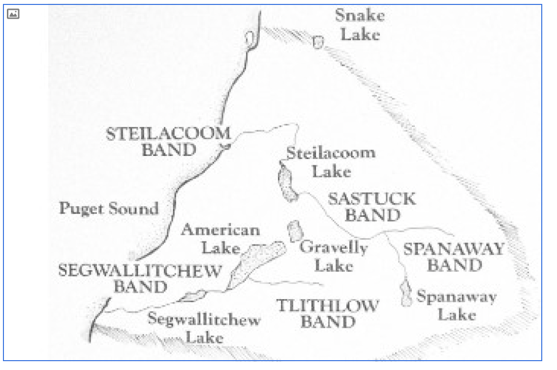
DESCRIBING: A horizontal black-and-white map.
DESCRIPTION: No description provided.
RELATED TEXT: Before Euro-American explorers and settlers first stepped foot in the Pacific Northwest, the Steilacoom people lived in the Tacoma Basin southwest of present-day Tacoma [it’s the plain between South Tacoma and DuPont]. Though small in number [roughly 600 members], the Steilacoom Tribe was part of the Coast Salish Indians and spoke Lushootseed. Its main village was located off Chambers Bay to our west, the site of the town of Steilacoom today. The Steilacoom Territory’s principal feature was a “group of spirit inhabited lakes.
This plain the Steilacoom people lived on was home to a pink flower called Indian Pink
(Lythophragma Parviflorum). The name Steilacoom roughly translates to People of the Indian Pink area. Today, the flower is also known as the fringecup or small-flowered woodland star.
↑ back to top
TEXT: We’re currently traveling through the City of Lakewood, home to over 60,000 residents.
At about 30 years old [incorporated 1996], Lakewood serves as both a retail and residential link between Tacoma to the north and Joint Base Lewis-McChord (JBLM) to the southeast. Sounder trains take commuters from here in Lakewood north to Seattle. There’s a second Sounder commuter line from Seattle that travels north to Everett, about 70 miles from our present location.
↑ back to top
TEXT: The first Army installation on Puget Sound was just west of here: Fort Steilacoom. It was established soon after the Treaty with Britain that determined which nation controlled what in the Pacific Northwest. The Army responded by sending troops West to establish outposts.
Fort Steilacoom was among the first, in 1849; at first its site was rented from the adjacent British Hudson Bay Company post. The historic fort was in operation for about 20 years. It promoted the migration of American settlers into the Washington Territory and built many of the first roads connecting the earliest villages.
Many of its buildings survive. Historic Fort Steilacoom is available for tours, sometimes with living reenactors, and is well-worth your time if you’re visiting nearby Tacoma or JBLM.
One of the notable soldiers stationed at Fort Steilacoom was Capt. George Pickett. If you are a history buff, you may recall Pickett had an early role in the Pig War on San Juan Island to our north. The Pig War was a conflict which almost brought the U.S. and Great Britain into a third war in less than 100 years, all because an American settler killed a trespassing pig belonging to the Hudson’s Bay Company.
More famously, he was the general of the failed tactical maneuver that bears his name – Pickett’s Charge – at the Battle of Gettysburg during the Civil War [often referred to as the highwater mark of the Confederacy].
Historic Fort Steilacoom is available for tours, sometimes with living reenactors, and is well-worth your time if you’re visiting nearby Tacoma or JBLM.
↑ back to top
TEXT: A handful of times on our journey between Seattle and Portland, our train parallels, or crosses Interstate 5. This is the north-south freeway stretching 1,380 miles without one stop light from the Mexican border [San Ysidro CA] to the Canadian border [Blaine WA]. This highway touches the capital cities of all 3 Western States as does the Starlight – Olympia, WA, Salem, OR, and Sacramento, CA. For about the next ten miles, the Coast Starlight and I-5 [“eye-five”] share the same corridor.
I-5 is a small part of our nation’s Interstate Highway System, connecting individuals and commerce from across the region or across the nation.
Can you believe railroads in the United States have been moving passengers and freight since before the Civil War? Freeways, like I-5, are a part of the Interstate Highway System, a system not envisioned until shortly before World War II.
Have you ever considered what travel methods predated railroads? Horses? Perhaps wagons? In Western Washington, there were many paths on land created by and traversed by Native Americans. It was not uncommon for Native Americans and later Euro-Americans to travel by boat on local waterways – rivers or our nearby Puget Sound to the west. The water was their highway.
↑ back to top
TEXT: Does anyone have a friend or close family member who has served in the U.S. military? Have you yourself served in the military? If so, thank you for your service or for supporting the service of a loved one.
The Department of Defense’s largest military base on the west coast sprawls in front of us on both sides is Joint Base Lewis-McChord [or JBLM for short]. Like many adjacent installations around the country, the U.S. Air Force’s McChord Air Force Base and the U.S. Army’s Fort Lewis merged in 2010.
JBLM has a population over 100,000, comprised of 40,000 active-duty soldiers and airmen, 60,000 family members, and 15,000 civilian and contract employees.
JBLM is a training and mobilization center for all services and is the only Army power - projection platform west of the Rocky Mountains.
↑ back to top
TEXT: We’re now traveling adjacent to the McChord Field part of Joint Base Lewis McChord (out of direct view). Its mission is primarily military support, especially worldwide cargo lift.
McChord is home to the 62nd Air Wing and its Reserve partner, the 446th Air Wing. Together, they fly 50 C-17 Globemaster III aircraft in support of combat operations. The large aircraft are known for their ability to use short runways and can rapidly carry equipment, supplies, and troops long distances.
C-17s are occasionally spotted overhead; look for gray high-winged aircraft with four engines and a tail shaped like a T.
Also based here is what’s known as the Western Air Defense Sector (or “WADS”), run by the Washington Air National Guard, which continuously monitors western North American airspace. For example, remember those Chinese balloons of several years ago? WADS tracked them. Another surprising story: on 9-11 2001, it was a young Air Guardswoman on duty at WADS who shut down all air traffic over the western U.S. and Pacific Ocean.
JBLM serves as a military training and mobilization center. But when called upon, men and women from McChord, Murray and Lewis have provided humanitarian relief to civilians at home and abroad during hurricanes, floods, fires, famine and earthquakes.
↑ back to top
TEXT: Next on both right and left is the sprawling and strategic Fort Lewis, one of the largest Army posts in the country. Its historic entry gate might be briefly glimpsed on the left. It was founded as Camp Lewis during the First World War, deeded by Pierce County to the federal government, and named, of course, after Army Captain Meriwether Lewis of Lewis and Clark fame.
Fort Lewis houses Army infantry, aviation, artillery and special forces units the Army’s only power-projection platform. Most notable is a brigade that deploys to battle zones with the 8-wheeled armored fighting vehicle, the Stryker.
↑ back to top
TEXT: Perhaps you can see the high-rise building to our east at JBLM. It’s Madigan Army Medical Center, a state-of-the-art medical complex that supports active-duty service members, their families, and veterans by providing both in-patient and outpatient care. It is the U.S. Army’s second largest medical treatment facility.
↑ back to top
TEXT: Now keep an eye out the right side of the train for the headquarters complex of the Washington National Guard, known as Camp Murray. The National Guard is a state-based Air and Army military force. You’ll first see an F-101B Bomber/Interceptor plane, plus a helicopter and M47 Patton tank. Then catch “The Minuteman,” a replica of Daniel Chester French’s famous statue at Concord MA.
It stands in front of the historic headquarters building dating to the 1920s. Immediately beyond is the historic Arsenal building, dating to the 19-teens, the very first military building in this whole stretch. It now houses a National Guard Museum, newly reopened to the public. Camp Murray also hosts the headquarters of Washington’s State Patrol and Emergency Management agency.
↑ back to top
TEXT: Approaching on the right side of the train, surrounded by vintage army equipment, is a landmark structure. When it opened in 1917 it was known as the Red Shield Inn, one of many hotels built by the Salvation Army as lodging for family visitors to soldiers training at Camp Lewis during the First World War.
Built in the style of a Swiss chalet, the Inn was part of an array of rest and recreation facilities constructed next to the brand new training site. In the 1920s the Army took it over as temporary officer housing; General Dwight Eisenhower stayed here on a visit just after World War II.
Since 1973 this historic building – now on the National Register of Historic Places – has housed the Lewis Army Museum, which interprets the history of the U.S. military in the Pacific Northwest beginning with the Lewis & Clark Expedition. It’s open to the public on a limited schedule: check ahead before you stop by.
One interesting exhibit is the last jeep driven on the post – delivered personally by the Fort Lewis commander, General H. Norman Schwarzkopf Jr. General Schwarzkopf later commanded the coalition forces in the First Gulf War.
The museum is open to visitors, but we strongly urge you to Google Lewis Army Museum to learn about the requirements to visit the facility.
↑ back to top
TEXT: Before military installations sprouted across these prairies, even before American settlers showed up, there was another so-called fort a short way west of here: Fort Nisqually, established in 1833 – first right on the shore, then on the bluff above. This was NOT a military post, but a key trading center for the British Hudson Bay Company, a continent-spanning fur operation. Hence English, Scots and French-Canadians were the first Euro-American settlers here. They intermarried as well as traded with the local tribes. They aided the first groups of American settlers north of the Columbia. They set up a farm outside the fort, a company subsidiary named the Puget Sound’s Agricultural Company, to grow crops and livestock for local consumption and export to Alaska, Hawaii, Spanish California, Europe, and Asia. They welcomed Native Americans as farm employees, friends, customers, fur traders, and often as spouses!
With the signing of the Oregon Treaty in 1846, the land surrounding several Hudson’s Bay Company trading posts, including Fort Nisqually, became U.S. territory and the posts would eventually close.
You can visit this trading post – but not here! Back in Tacoma, at Point Defiance Park, a replica has been constructed that includes a couple original buildings.
The original site of Fort Nisqually was recently developed as a golf course. To see these original sites, with very helpful signage, you can hike the old trail to the Sound from the DuPont City Hall parking lot.
↑ back to top
TEXT: And here we are at DuPont. If that name sounds familiar, it’s not a coincidence: The DuPont Company of Delaware founded it as a company town in the early 20th Century [1906]. The DuPont Company manufactured black powder and other explosives.
The townsite and factories extended west to Puget Sound. The village known as “historic DuPont” was incorporated in the mid-20th century [1951] but had a population of only about 600 as late as 1990.
In 1976, the Weyerhaeuser Timber Company purchased most of the DuPont company land with plans for a major sawmill. When the lumber market faded, Weyerhaeuser pivoted to developing a planned community of retail, residential, and industrial properties. Subsequently, the population has blossomed to over 9,000 residents.
Next time you find yourself in this area, we’d encourage you to visit the DuPont Historical Museum, a short drive from the center of DuPont and JBLM.
↑ back to top
TEXT: As we cross over I-5, we drop down off the Lakewood Prairie and enter the Nisqually River Valley. Here we rejoin the BNSF mainline and will stay on this track to Portland.
Weather permitting, we may briefly have a view of South Puget Sound and the Olympic Mountains to our west.
↑ back to top
TEXT: Off in the distance on the northwest side of the train is Puget Sound. It’s not a lake, but a saltwater inlet of the Pacific Ocean formed by the advance and retreat of Glaciers some 13,000 to 15,000 years ago. It is the second largest estuary in the United States [after Chesapeake Bay] where the saltwater of the Pacific Ocean mixes with freshwater from the 10,000 rivers, lakes, and streams of the surrounding watershed.
One of the reasons you should consider visiting Puget Sound by beach or by boat, is that it’s a fantastic place for recreation, be it swimming, boating, fishing, or sightseeing.
Puget Sound is part of the Salish Sea, which also includes the Strait of Juan de Fuca and the Strait of Georgia. This area in view is known as South Puget Sound.
[Definition of “Sound” {noun}: “A narrow stretch of water forming an inlet or connecting two wider areas of water such as two seas or a sea and a lake.”]
↑ back to top
TEXT: For a short time, in the distance on the northwest side of the train, we have a view of one of America’s smallest but most spectacular ranges, the Olympic Mountains (occasionally visible to our east) in Olympic National Park. Do you enjoy camping, hiking, wildlife viewing, night sky viewing, cycling, or beachcombing? If so, Olympic National Park is fantastic place for you to visit. There aren’t many locations in which one can enjoy mountains, waterfalls, and ocean beaches all in the same National Park.
At 10 to 15 million years old, this coastal range of the Olympics is much younger than the Cascade Range to our east [which is about 50 to 100 million years old]. These mountains were formed as the oceanic plate sank under the continental plate, lifting parts of the ocean floor far above the surface. Marine fossils can be found high on the mountain slopes. At approximately 8,000 feet, Mount Olympus is the highest peak in the Olympic Range.
↑ back to top
TEXT: The Nisqually tribal members refer to themselves as "people of the river, people of the grass."
The ancestral home of the Nisqually Tribe once comprised the lands within the Nisqually River Watershed. They had stretched from Mount Rainier to our southeast, from their northwest to the present-day City of DuPont, then south to Tenino. What was once an area comprising approx. 3,100 square miles has been reduced to a reservation of about 8 square miles following the signing of the 1854 Medicine Creek Treaty and the 1855-56 Puget Sound Indian Wars.
Unfortunately, about 70% of the land is now located on Joint Base Lewis-McChord which limits access by the Nisqually people. During World War I, Pierce County gave the federal government over 5 square miles of the reservation, to create Camp Lewis (now JBLM). Then, the U.S. Army expelled the Nisqually members. How would you feel if someone took your home or farm and gave it to others without your input?
“The Nisqually have always been a fishing people and the reservation is located on the Nisqually River to our east.
The Nisqually argued for years to have their fishing rights restored that the State of Washington took away. In the 1960s and 70s, they engaged in civil disobedience, including “fish-ins.” They ultimately won their right to fish thanks to the federal court case known as the Boldt decision.
Subsequently, through the lobbying of Billy Frank, Jr. and the efforts of federal politicians, one of the state’s largest fish rearing facilities, the Clear Creek Hatchery, was built on JBLM property
(Nisqually reservation land). Today, the hatchery has helped to repopulate the nearby Clear Creek with fish and support salmon fisherman locally.
Today, the Nisqually Tribe “has more than 650 enrolled members, the majority of whom live on or near the reservation.” It’s “an entrepreneurial tribe that has grown to become one of the largest employers in Thurston County, while building a national reputation for [its] environmental stewardship programs protecting and enhancing [the] natural environment … .”
↑ back to top
TEXT: We are traveling through the Billy Frank, Jr. Nisqually National Wildlife Refuge and will soon cross over the Nisqually River. The river originated off the Nisqually Glacier on Mount Rainier to our east. The Refuge and Nisqually River Delta is principally to our west and extends to Puget Sound (out of our view).
A wide variety of sea life, birds, and other mammals are hosted here at varying times throughout the year, as the Nisqually River Delta is one of Puget Sound's most significant ecological crossroads. The Refuge is an estuary, that is, a transition zone between land and sea where freshwater rivers and streams meet and mix with the salt water, forming a melting pot of organic and mineral nutrients. The nutrient-rich soup of the estuary nourishes plankton and plants, which in turn nourish oysters, clams, crabs, salmon, and birds. Acre for acre, estuaries are among the most biologically productive ecosystems on earth. It also gives migrating salmon a transition from fresh to salt water.
Over 130,000 people visit the refuge and its interpretative center annually. A two-mile long path and an ADA compliant boardwalk allow visitors to walk within the marshland.
The refuge was recently [2016] renamed to honor Billy Frank Jr. He was a member of the Nisqually Indian Tribe and worked to have Native American fishing rights enforced that were granted in the treaties signed between the United States and the Puget Sound Native American Nations. These 1850s treaties said Native Americans would have access to their traditional fishing areas in common with the settlers, including off-reservation fishing grounds. However, the State of Washington continually arrested tribal members for exercising their treaty-granted fishing rights. The lawsuit Frank championed focused on the Nisqually and Puyallup Tribes and led to U.S. District Court Judge George Boldt’s decision that the harvest must be equally divided between the Native Americans (known as the treaty-tribe fishery) and the all citizen fishery. The Boldt Decision was eventually extended to other tribes.
Billy Frank Jr, originally an ‘outlaw’ to law enforcement, was awarded the Presidential Medal of Freedom in 2015 with these words: “Frank left in his wake an Indian Country strengthened by greater sovereignty and a nation fortified by his example of service to one’s community, his humility, and his dedication to the principles of human rights and environmental sustainability."
The Billy Frank Jr. Nisqually National Wildlife Refuge encompasses an area of almost 3,000 acres [2,925 acres].
Washington’s last big earthquake [magnitude 6.8], about 20 years ago [2001] is known as the Nisqually Quake and occurred 30 miles under this region. This location also had a major quake [magnitude 7.1] in 1949.
↑ back to top
TEXT: Nearby, the Medicine Creek Treaty was signed shortly before the Civil War [1854], by Washington’s first Territorial Governor, Isaac Stevens. The treaty required the Nisqually, Puyallup, and seven other Native American groups to give up most of their land and move onto reservations as one tribe. The land assigned to them was insufficient to support their way of life. The terms of the treaty, and whether Native American signatories fully understood or even signed the treaty, caused conflict that led to the Native American War [skirmishes] of the mid-1850s [1855 and 1856].
Today, Medicine Creek is now principally known as McAlister Creek and runs along the most westerly side of the delta. The train crosses over what might be described as the headwaters of Medicine Creek – the first creek to the south of the trestle over the Nisqually River by about a half mile.
↑ back to top
TEXT: We’re crossing Pattison Lake and the state capitol is about six miles northwest of us. Lake Pattison is essentially a large mud puddle, it has no specific inlet or outlet river or stream. Pattison Lake was once the site of vacation resorts during the 1910s through the 1930s. These resorts were popular with tourists from Tacoma and Seattle. Olympia was first settled in 1846 by Levi Lathrop Smith and Edmund Sylvester who had arrived from New England. Smith called the settlement Smithfield, renamed Olympia in 1850 by Sylvester after Smith died. In 1853, the Washington Territory was created and Olympia became the capital.
↑ back to top
TEXT: Nisqually River
TEXT: We will soon cross the Nisqually River which has its source high on the slopes of Mount Rainier on the Nisqually Glacier. Here, we find another incidence where the name of the river, the glacier from which it originates, and the name of Native Americans who were indigenous to the area, all match. We are now skirting the northern boundary of the Nisqually Indian Reservation. As we cross high above the river, let’s watch to see if people are fishing today! The tribe fought in the 1970s to enforce the Nisqually Peoples’ right to fish here, as promised in the several treaties signed between the United States and the Native American Nations. This effort was led by Billy Frank Jr. which increased recognition nationwide of the need to respect and honor native treaty rights.
↑ back to top
State of Washington
As we leave this strategic military corridor and the Nisqually estuary, and now approach the state capital, reflect on the changing landscape of the whole Pacific Northwest.
What is now the State of Washington started out, of course, as land that was home to an array of indigenous tribes and bands. The Spanish, Russians, British and Americans all laid claim to what they called “Oregon Country.” Treaties took Spain and Russia out of the picture, leaving what was called the Oregon country to be divided between Britain and the U.S. In 1846 the two nations split the difference at the 49th parallel.
North of the line was called British Columbia, after the river
The whole area to the south – from the Pacific to the Rockies, became America’s organized Oregon Territory.
Washington Territory was carved out in 1853
Treaties in the 1850s reserved sovereign lands to the various tribes –we’ll come back to that story shortly
Oregon became a separate state in 1859
Idaho split off to become a separate organized territory in 1863
Washington and Idaho were admitted as states in 1889 and 1890
↑ back to top
TEXT: Olympia was first settled in the mid-1840s [1846] by Levi Lathrop Smith and Edmund Sylvester who had arrived from New England. Smith originally named the settlement Smithfield. In 1850, after Smith had died, Sylvester renamed the settlement Olympia. Shortly thereafter [1853], the Washington Territory was created and Olympia became its capitol.
The town was named after Mount Olympus in the nearby Olympic Range. It wasn’t much of a place back then: One settler described early day Olympia as a couple dozen log cabins, a mud street, and a saloon that consisted of a keg and three glasses.
In its early years, Olympia was the largest settlement in Western Washington. It has long since been surpassed in size and commercial importance by Tacoma and Seattle, but it remains the center of political activity in Washington.
↑ back to top
TEXT: This is Centennial Station at Olympia/Lacey was named to commemorate Washington's 100th anniversary of its statehood in the late 1980s [1989]. Ten Amtrak Cascades trains and two Coast Starlight trains arrive and depart daily. It is staffed by over 50 volunteers, 365 days a year, opening at 8 a.m. and closing after the last train departs and the station. There are currently 14 trains a day: 12 Amtrak Cascades and two Coast Starlights. The passenger count for F.F.Y. 2024 (October 2023-September 2024) was just over 71,000. It is the fourth busiest in Washington State.
The people at Centennial Station are role models for wanting to right a wrong and volunteering. In the 1980s, this area was served by not much more than a small, three-sided wood structure (perhaps the size of a bus shelter). It was surrounded by railroad ballast, the lighting was poor, and public transportation was minimal (if it existed at all). Late one night, a train stopped here and dropped off a lone passenger in a wheelchair. No one was waiting for him. The ground surface was so bad, he couldn’t move his wheelchair and he was forced to spend the night before someone showed up the next day to provide assistance. People in Olympia wanted to make sure the indignity that befell this traveler was never repeated.
One of the first goals was to build a proper train station. The land was purchased for one dollar. The volunteers planned the facility, donated money and materials towards its construction, and contributed their labor to build the station. Centennial Station opened in the early-1990s.
The station has been continuously s by volunteers since it opened nearly 30 years ago – they’ve yet to miss a train’s arrival or departure. Their goal is to make sure that no passenger is left without someone to provide assistance – perhaps help getting out of the rain or tracking down transportation.
The nearly 3,000 [2,800] square foot station was designed in the manner of a classic rail station. It features state of the art energy conservation construction. The decorative corbels under the roof are the only “old” construction. These were obtained from New Orleans, and are made of solid cypress, over 150 years old, having been saved from houses on Cherokee Street. Some 2,500 paving bricks were sold at $35 to $50 apiece, while marble plaques were minted for larger, business donors. The local contractors' trade association donated time and material. An architect Harold Dalke contributed drawings. Bob Bregent who served as the project manager during the construction of the station, would show up with half a dozen volunteer nail-pounders on Saturdays and Sundays.
↑ back to top
TEXT: Less than a quarter mile south of the station, just beyond the highway overpass, we will see the Country Greens turf farm on our left. Country Greens has nearly 700 [660] acres of turf growing in three Western Washington Farms.
Visibility permitting, an outstanding photo opportunity to capture Mount Rainier with a carpet of green grass in the foreground presents itself just south of here! Notice the three peaks, from left to right, Liberty Cap 14,112’; Columbia Crest 14,410’; and Point Success 14,158’.
↑ back to top
TEXT: The plant with the bright yellow flowers is Scotch Broom [Sarothamnus scoparius] a perennial shrub is native to western and central Europe. In the United States, it is generally considered an invasive species. In the Pacific Northwest, it chokes out trees and costs millions in lost tree production each year. It can also be toxic to critters when eaten in large quantities.
↑ back to top
TEXT: Ahead we will begin to see hundreds of lumps on the valley floor. These are the mysterious Mima Mounds which originally covered nearly 20 square miles. They can be found in nearly every state west of the Mississippi river and yet scientists are still stumped as to what caused them.
Early Euro-American settlers thought these might be native burial grounds, but when opened, the mounds revealed no such evidence, only rock and sand. Today there are more than 30 theories on origin of the mounds, including 1. Deposits of glacial outwash from the receding glaciers. 2. Remnants of soil left following seismic activity. There's even a theory that gophers -- a lot of them over 800 to 1,000 years -- moved in and as they dug their chambers, tossed a great deal of sand and pebbles upward, forging mounds.
Although they originally covered nearly 20 square miles, farming and settlement activity smoothed out much of the area. Similar structures found elsewhere in the Pacific Northwest, as well as in Texas, Baja California, Colorado, Australia and many other places around the world. This area is also one of Western Washington’s prime butterfly habitats in summer.
The Mima Mounds were a major food source for the local Native American tribes. Early in the spring, the low areas around the mounds would gather water, creating pools. These wet areas would first bear the edible camas [CA-mus] root, which was a staple in the diet of the native people. Later in the spring and summer, camas would grow further up the mounds. Since the white camas is poisonous, those are dug up and discarded when in bloom. The remaining blue camas was harvested later in the season. Camas roots were cooked, mashed and dried, then made into cakes for long-term storage. Later in the summer, coastal strawberries would grow on top of the mounds, a sort of successional farming, thus creating an even greater food store. These mounds were routinely cleared of trees and shrubs, allowing the camas and strawberries to mature in full sunlight.
The town of Mima was a stop on the Northern Pacific Railroad and the first post office [1893] was called Mima Prairie. It is thought that the name is an Indian word meaning “a little further along” (Meany).
↑ back to top
2020: Olympia to Kelso/Longview: CS 11:11 AM to 12:19 PM; 62 miles; 1 hour, 8 minutes
1854: Cowlitz Landing [half way between Centralia and Kelso] to Olympia: three days.
In 1854, Isaac Stevens, named the governor of the new territory, brought his wife Meg and their four children from their home in Newport, Rhode Island, a whaling town with fine homes, to the new Washington Territory. They traveled to Panama by steam ship, crossed the Isthmus by train and mules, followed by ship up the west coast of Mexico and California arriving at Fort Vancouver in mid-November. The hundred miles from Vancouver to Olympia were the most challenging: Day 1: By boat to the Kelso area; Day 2: by crowded canoe up the Cowlitz River as far as possible; Days 3, 4, and 5: on wagon and foot. The old Native American foot trails were less than suitable for wagon travel, to say the least. One description of the final 40 or so miles and three days of the journey follows:
The next morning everyone piled into wagons. And soon the horses were sinking deep into the mud with every step. Rivers were fjorded with water coming up over the wagon bed, and the drivers jumping the team across wide holes brought the springless wagon down with tremendous impact. “Surely,” Meg shuddered, “there were no worse roads to be found in the world.” Finally, when the team could not negotiate one of the larger holes, the wagon sank deep into the morass. The difficulties of the journey were commonplace to the governor, but to his wife the initial introduction to the primitiveness of the territory that she had heard described in such glowing terms came as a rude shock. For two more days they continued toward Olympia over roads that improved somewhat as they neared the capitol. But then came the final disappointment. Cresting a small rise on a dreary December evening, they looked down the muddy road at a clearing of tangled timber and tree stumps which contained a scattering of twenty or thirty rough-hewn cabins and an Indian village: Olympia. Meg’s heart “sank with bitter disappointment” as she surveyed the dismal site of their new home.
↑ back to top
TEXT: Take a look at the train we are passing right now. It looks like it is carrying containers that we are used to seeing containing consumer goods from Asia and perhaps returning to Asia with agricultural products from the United States. However, if you look carefully, you’ll see that the tops of the containers are covered by tarps, not solid such as with normal shipping containers. This train consists of solid waste from a number of the largest cities in Western Washington. The smaller containers are filled with non-recyclable construction waste.
A modern sanitary landfill it is expensive to build and larger cities have no room to put them. A large landfill has been built about the 100 miles up the Columbia River from Vancouver at Roosevelt Washington. It is on top of some 340 feet of low permeability natural clay, the bottom of the landfill is 1,500 feet above the closest regional aquifer Roosevelt has only about six to nine inches of rain a year which greatly reduces the chance of water leaching through the solid waste. The containers are removed from the train and trucked to the top of the bluff and emptied into the landfill and covered with dirt. The captured methane gas from the decaying solid waste is used to produce electricity for about 30,000 homes. It can accept about 30,000,000 tons per year and has an estimated 50 year life.
↑ back to top
TEXT: In the early-1870s [1872], the Northern Pacific Railroad established a junction here 15 miles south of Olympia. Its name, Tenino, comes from a Chinookan word meaning “meeting place” or “fork in the road,” referring to the junction of military roads between Fort Vancouver, Olympia, and Steilacoom.
On the west side of the tracks, here at the southern end of the Mima Mounds, we are approximately 2½ miles north of Tenino. In the late-summer of 1969, less than two weeks after the famous Woodstock Festival, this field was the site of the Sky River Rock Festival [first held the year before in Sultan Washington]. The festival featured what were then, and some still, anonymous American bands; Country Joe and the Fish, Steve Miller, Flying Burrito Brothers, Youngbloods, and Black Snake. Though an estimated 25,000 concertgoers attended over a three-day period, the festival still lost money.
↑ back to top
TEXT: Bucoda [Boo-Cota] was established by Aaron Webster in the mid-1850s [1856], who used water from the Skookumchuck River to operate a sawmill nearby. The area originally bore the name of its infamous prison, Seatco. Seatco is a native American word meaning devil or ghost. The prison was established by the Pierce and Thurston county sheriffs with private funding. During the 11 years of the prison’s existence in the late-1870s through the late 1880s [1877-1888], the inmates were contracted out as laborers to the local mills and mines for $0.70 per day. The sheriffs and businessman that provided the funding made a substantial profit. Conditions at the prison were poor to say the least, one prisoner referring to Seatco as “Washington’s hell on earth.” Seatco was renamed by the Washington Legislature in 1890 for the first two letters of the principals’ last names in the town's mining business: James M. Buckley, Samuel Coulter, and John B. David.
↑ back to top
We are currently traveling through Lewis County. About three quarters (¾) of it is mountainous and forested, while the remainder is prominently fertile plains and fields (ideal for agriculture), rivers, and streams.
The major population centers are Centralia and Chehalis, but the county also contains portions of Snoqualmie National Forest, Gifford Pinchot National Forest, and Mount Rainier National Park. This area is ideal for outdoor recreation.
The original inhabitants were members of the Cowlitz and Chehalis Native American Tribes. With westward expansion, European Americans moved into the area. In the 1820s [1825], the Hudson’s Bay Company established a farm on the Cowlitz Prairie in the 1820s and its overseer was Dr. John McLoughlin.
The Oregon Territorial Government created Lewis County in the 1840s, naming it after explorer, Meriwether Lewis. Would you believe its original boundaries stretched from the southern boundary of Russian Alaska in the north to the Columbia River in the south and from the Pacific Ocean to the Cascades? Today, the county is much more compact at about 25 miles from its north boundary to its southern and about 90 miles from east to west.
↑ back to top
TEXT: George Washington was born in Virginia shortly before 1820 [1817], the son of an enslaved black man and a white woman. George migrated to this area with his foster parents, the family of James and Anna Cochrane in the early 1850s [1852]. He tried his hand at logging and farming, and, lived several places around Centralia including Portland, Cowlitz landing and the present day Chehalis. In the early-1970s [1872], believing the new rail line then being built between the Columbia River and Tacoma would pass over land he had homesteaded, George filed a plat for a new town site on his land which was near the regional stagecoach stop. At the time, it was named Skookumchuck [SKOO-come-chuck] after the nearby river.
Located near the midpoint between Portland and Puget Sound, Washington named his new town Centerville. Because there was already a town of Centerville in Washington [present day Stanwood], Centerville was renamed Centralia in the mid-1880s [1884]. George Washington’s hunch about the railroad track proved to be a sound one and his town thrived and he prospered from the sale of building lots.
For decades, Centralia has been a busy lumbering center, as well as a railroad junction for lines to Grays and Willapa [WILL-uh-puh] Harbors on the Pacific coast. Millions of board feet of timber and thousands of carloads of oysters and Pacific beach cranberries have been shipped through here over the years. Downtown Centralia has become a major venue for antiques and is an excellent Amtrak day trip from Seattle or Portland.
Centralia’s train station was built by the Northern Pacific shortly before World War 1 [1912] and renovated in the 1990s. The time of its opening was prosperous for Centralia, and a ceremony was made of dedicating the new depot, public library, and the Dumon Building downtown. Festivities included the city’s first airman attempting to drop a bottle of champagne on each of them, something akin to the nautical tradition of ship christening. Unfortunately, only one hit the station, and breaking a few of the roof tiles.
The airman who dropped that bottle of champagne on the new Centralia station was Claude Berlin. At that time, aviation was in its infancy — less than ten years after the Wright Brothers first flight at Kitty Hawk, North Carolina, and Berlin must have had extraordinary courage. But he was not just a daredevil: he went on to become an executive in the Boeing Company.
It was Claude Berlin who, during World War I [1917], sent the famous telegram from Pensacola, Florida advising Bill Boeing that the U.S. Navy was about to place its first order for Boeing airplanes. It read: “Advise you get ready for big business. Everything points to big order. They ask how soon we could turn out twenty machines like these.”
He was referring to Boeing’s Model C seaplane trainer, the second plane developed by the Boeing Airplane Co. (The first was the B&W [named for company founders Bill Boeing & George Westervelt], a float plane, which had its first flight a year earlier [1916]. The company was incorporated as Pacific Aero Products Co. a month later and changed its name the following year.
Berlin later became manager of Boeing’s Seattle assembly plant.
As we pull out of the station look to your right and you'll see some umbrellas and hanging lights. Today, this is the Olympic Club hotel. In 1921 it was the Oxford Hotel. It was here that the public enemy #1 of the time was captured by a hotel employee and a rookie Centralia cop.
Roy Gardner was a serial train robber, a rare crime today, which probably accounts for Gardner's relative obscurity. In his career stole over $350,000 in cash and securities. He was handsome, charismatic, and sly as a fox. Nicknamed "the smiling bandit." He was renowned an escape artist. In 1920 he was sentenced to McNeil Island Federal Penitentiary, transported there via train. He tricked his guards, shackled them, robbed them, and made his escape. He continued his crime spree, was caught again, and sentenced to 25 more years at McNeil.
On his way back again to McNeil he devised a ruse, procured a gun, disarmed and robbed his guards and jumped off the train near Castle Rock. It was June 15, 1921. Gardner road the cowcatcher of a northbound train and got off in Centralia. He wrapped his head in bandages and told the staff at the Oxford Hotel that he had been burned in an industrial accident in Tacoma. Hotel employee Gertrude Howell and rookie copy Louis Sonney suspected his real identity and made the collar.
Gardner got another 25 years added to his sentence, and finally got to McNeil, but six weeks after arriving at the prison escaped yet again, during a baseball game. He was recaptured and eventually transferred to Leavenworth, then to Alcatraz, the escape-proof prison. You can read all about it in the Olympic Club Hotel and can even stay in the Roy Gardner room!
↑ back to top
TEXT: This is Chehalis, named for the nearby river, and the local Native American people. The Northern Pacific Railway Station on our left is now the Lewis County Museum. I.P Callison maintains a mint processing plant in Chehalis that produces locally grown and internationally sourced mint into a concentrate included in gum, toothpaste, and a wide range of other products.
The story of the town’s founding provides a nice illustration to the feistiness and resourcefulness of the people who traveled the Oregon Trail and settled the northwest.
A couple named Saunders settled here in 1850. Soon thereafter, they claimed 320 acres under the Oregon Donation Land Act; 160 in the husband’s name; 160 in the wife’s. Their claim was within what was essentially a muddy marsh. The mud limited transportation in a wide area and roads were basically out of the question. Starting in the mid-1860s [1866] a riverboat service on the Chehalis and Black rivers got within ten miles of present-day Tumwater on Southern Puget Sound. Even so, getting to or from markets on Puget Sound meant an arduous day-long trip in each direction.
In the mid-1870s [1873], the Northern Pacific Railroad completed its line between the Columbia River and Tacoma. Suddenly, Puget Sound was only a few easy hours away, and large quantities of goods could be cheaply shipped. Unfortunately, the railroad would not agree to stop in Chehalis. The railroad official in charge of construction wanted the town to donate land for a station.
The owner of the land refused. Who was this defiant owner? None other than Eliza Saunders, now divorced from her husband, and in full and sole possession of the land she gained in her Oregon Land Donation claim.
In the face of this defiance, the railroad announced it would build a station three miles away on land secretly owned by a railroad construction official. The only way for the people of Chehalis to get to this proposed site was to walk between the tracks over the trestle the railroad built to get the tracks up and out of the swamp. An impasse ensued. What to do? A local lawyer remembered that a law required any and all trains to stop when a red flag was shown. Those who had begged the official to reconsider cleverly equipped townspeople with flags, and every train was stopped. Eventually, the Northern Pacific decided it was easier to put a station in the town than deal with service interruptions.
↑ back to top
TEXT: On the east side of the train and forward, to the far southeast, we get our best view of Mount St. Helens, which experienced a cataclysmic eruption in 1980 [May 18, 1980]. It lost about 1,300 feet, reducing its elevation from about 9,700 feet [9,677 feet] to about 8,400 feet [8,346 feet]. The cloud of ash spread eastward, circling the globe. Today, visitors at the Mount St. Helens National Volcanic Monument can see the blowout zone on the north side of the mountain. Recent rumblings, steam vents, and lava flow activities give testimony to the term “active” volcano.
With climate change, it’s not uncommon to hear that over 90% of the world’s glaciers are retreating. If there’s not enough snow that feeds a glacier to offset its loss of mass as it melts, a glacier will retreat. Very rarely do glaciers grow (perhaps 1% of the time). Can you name a location in the Lower 48 where a glacier is growing?
Although we often hear about the declining glaciers on Mount Rainier and in Glacier National Park, inside the crater of Mount St. Helens, a glacier is growing. It is located within the crater left by the 1980 eruption, in the shadow of the wall. In spite of the heat still generated by the lava dome building in the crater, it reached sufficient mass to start moving by the mid-Nineties [1996]. Even though a second dome was formed in the mid-2000s [between 2004 and 2006], the glacier remains. It has been named the “Crater Glacier” and currently covers over 200 [236] surface acres. The ice averages over 300 [328] feet thick; the maximum is approaching 700 [656] feet.
During the summer months, visitors can travel on State Route 504 (the Mount St. Helens Highway) about 50 miles east of I-5 at Castle Rock to visit the Johnston Ridge Observatory on an overlook just to the north of the mountain. The trip to the Mount St. Helens National Volcanic Monument is well worth your time.
↑ back to top
TEXT: Since our departure from Seattle, we have been traveling on mostly flat land carved out by glaciers that advanced and retreated over the Pacific Northwest between 21,000 and 11,000 years ago. The glaciers advanced to this area at the southern edge of the Chehalis Valley.
We will be leaving the Puget Lowlands and the Chehalis River Valley, and begin climbing Napavine Hill where we will reach the highest point on our route between Seattle and Portland, approaching 500 [455] feet. In the days of steam travel, extra locomotives would often be needed to move trains up the hill. As we descend, we’ll have made the historic crossing from waters draining into the Sound to those flowing into the Columbia River.
The land we will be seeing outside the window was once the bottom of the Pacific Ocean. But that was 100 million years ago according to geologists. The terrain we have been traveling over was shaped by conventional tectonic and erosion forces.
↑ back to top
TEXT: One hundred to one hundred and forty years ago, there were vast forests in western Washington, immense trees, from mountains to ocean. Why? Unusual climate: Dry summers, wet winters. Conifers outcompeted broadleafs as conifers have high photosynthetic activity in all seasons which resulted in enormous growth. Eastern lumbermen were in awe when they came here.
The trees were huge and the land was cheap. Five times as much wood/acre as in prime Great Lakes timber land. Trees were 350-400 feet tall and 500-1,200 years old. It took two loggers with steel axes a day or more to fell one tree. People of the time thought they could never cut all the giant timber. Douglas fir was king: it was hard, tough, great construction material. There were also huge redwoods, cedars and hemlocks.
From 1905-1930, Washington was the number one timber producing state and in 1914 the Bureau of Corporations reports that 63% of Washington residents depended directly or indirectly on logging. Technology improved: chain saws, logging railroads, hillside logging, aerial logging. Some half of society toiled 50 years to cut nearly all these immense trees. Within 50 years, 90% old-growth was cut "Old-growth" today doesn’t compare to that of past and now much smaller trees qualify as old growth. The old giants are long gone.
↑ back to top
TEXT: Today, we hardly give it a thought about traveling halfway across this country by plane (it only takes a few short hours). Can you imagine what travel was like 150 to 200 years ago during Westward Expansion (also known as the era of Manifest Destiny)?
For those that had enough money, they could take a voyage on a ship that sailed the Atlantic Ocean, south past the Caribbean, along the eastern shores of South America, before swinging around Chile’s Cape Horn, entering the Pacific Ocean, and traveling north to the West Coast of the present-day United States. The journey could easily take 200 days (unless they took a shortcut and traveled overland through Panama that could cut the passage to under 60 days).
For those without sufficient resources, travel out west was possible on one of the overland trails by wagon, horse, and/or walking. Routes by wagon that reached the West Coast included the California Trail (Missouri River to California) and Oregon Trail (Missouri to Oregon). The Oregon Trail (which we will focus on during today’s journey) could easily take five to six months (and that’s starting in Missouri). To give you an idea how challenging the Oregon Trail was, on average one in ten who started the journey didn’t survive. As an aside, stagecoach trips from Iowa to California cut the travel time to 25 days.
By about the 1870s, wagon trains and stagecoaches fell out of fashion as transcontinental railroads started crossing the west and could do so in just four days over about the same distance. For about 80 years, trains were the principal mode of long-distance travel in the Lower 48 (before they were supplanted by airplanes, cars, and buses).
How long do you think it takes to travel today from here to the Missouri or Mississippi Rivers by train, car, or bus? Perhaps two or three days?
↑ back to top
TEXT: The next three towns we visit, Napavine, Winlock, and Vader, were formed in conjunction with the building of the Northern Pacific Railroad from Kalama to Tacoma.
Napavine was once a thriving lumber town. Its name was taken from a Native American word, Napavoon, which meant “Small Prairie.” There is still a working lumber mill in town, Pacific Lumber Company, employing 20-50 people. Many residents work in the nearby cities of Chehalis, Centralia, and Olympia. There are approximately 70 [72] small businesses in town which provide common goods and services.
One of the establishments we’ll see on our ride through town is Frosty’s Tavern one of the oldest continuously operated saloons in Western Washington, having been opened around 1901 twelve years before the town was formed.
↑ back to top
TEXT: About 2 Miles South of Napavine
TEXT: We can see a different kind of tree farm with limbs that look like they have been chewed on by giant rabbits [and some have said they look like bottle brushes]. These trees are not grown for timber, but to supply boughs for Christmas wreaths and garlands. These Noble Fir trees are owned and tended by the Kirk Company of Washington. They have several plantations like this one totaling 800 acres.
The trees are planted in rows to allow easy tending. They are trimmed periodically to keep the height at about 25 feet. Boughs are harvested on a three-year rotation. This does not diminish the tree but spurs it to more bough growth.
In the background with the towers that look like an oil refinery is the Cardinal Industries float glass plant that produces window glass used throughout the west coast.
↑ back to top
TEXT: This is Winlock, self-described as the egg capital of Washington. On the right we will spot a famous local landmark—the"World’s Largest Egg.” In 1923, Winlock built this egg as a float in the parade that was held between Olympia, Washington, and Salem, Oregon, to celebrate the opening of the new Pacific Highway, the first through auto road connecting the state capitols of Olympia and Salem. After the parade ended, the egg was brought back to Winlock and displayed as a monument to the town’s egg and poultry industry. The 2022 weekend Egg Days community festival is traditionally scheduled for the last weekend in June.
From the 1920s through the 1950s, hundreds of carloads of eggs and baby chicks were shipped from here annually.
On the other side of the train is the downtown area, and some of the buildings which served the produce, egg, and poultry Co-Ops during Winlock’s heyday. The Egg was the largest in the world when it was built, but there are now others claiming the title in Alberta, Belgium, and Indiana.
Fun Facts about Winlock:
Farm crops grown in Winlock included hops, filberts, strawberries, and gooseberries. In 1922, Cowlitz Produce Company shipped out eleven carloads of strawberries.
In 1898, the first graduate of Winlock’s two-year High School was Charles Metsker, who is famous for his Washington State “Metsker Maps.”
In 1952, the Standard Hatchery, Inc. was turning out 750,000 chicks annually, and the total annual output of chicks in Winlock then was about four million.
The Egg Industry Begins
Winlock’s most notable industry was poultry and egg production. In 1887 William Warne moved to Winlock and purchased 100 laying hens and he sold his eggs around town and to the railroad men. In 1910, John Marcotte, an agent for the Northern Pacific, came to town and saw that the local farmers were selling their eggs to the local food stores, or trading the eggs for groceries. Marcotte had an idea. He went to Grays Harbor and struck a deal with a large lumber company to supply them with eggs, hogs, and veal. He then went to the farmers and told them he would buy all the eggs, hogs, and veal they could produce, and pay cash on the spot. He now had two sources of income; he made money on the resale to the lumbermen and profited from the commissions on his railroad express shipments! The egg and poultry business took off from there and between 1920 and 1950 Winlock was to become the second largest egg producer in the U.S, selling railcars of eggs as far away as New York!
↑ back to top
TEXT: Are there any fourth graders riding with us today. Or is there a fourth grader in your family, or do you know of any fourth graders – friends, neighbors, extended family. We want to make you aware of a very special program offered by the National Park Service that gives a fourth grader and their family FREE ACCESS for an entire year to hundreds of national park sites, as well as other Federal recreational lands. The cost of the annual America the Beautiful Pass is now $80, making this free Every Kid Outdoor Pass a real bargain. And, up to three adults (age 16 and older) and all kids (under age 16) in your car or group can get in free.
Free entry is not only to all National Parks Service units, but to other fee-based federal lands like national forests and national wildlife refuges. We have a pamphlet here that covers the details of how your fourth grader can obtain the free pass. It is an online process where the fourth grader completes a short exercise and prints out a paper voucher which can be used to enter the parks or be exchanged for a more durable Annual 4th Grade Pass.
One perk of the pass: You have the opportunity to cut down your Christmas tree for free in certain national forests. Families are granted a free tree permit with your Every Kid Outdoors Pass.
This special initiative is designed to nurture the next generation’s enthusiasm for protecting our national parks and public lands that are home to our country’s spectacular natural treasures, rich history, and vibrant culture.
↑ back to top
TEXT: Although there are several variations to the story of how Vader was named, they all follow a common theme.
The town of Vader was originally incorporated as “Little Falls” in 1906, in honor of the falls at nearby Olequa Creek [OH-la-kwa]. When the railroad built its depot about a mile south of town, they gave it an Indian name, “Sopenah.” As Little Falls grew, it moved in the direction of the depot and began to be called by both names. Confusion ensued, as there was already a “Little Falls,” Minnesota, along the Northern Pacific line. Freight shipments destined for “Little Falls” were often misrouted. Have you ever had your luggage misrouted when you traveled? If so, your experience is similar to others here over 100 years ago. The railroad demanded that the name “Little Falls” be changed. Some townsfolk suggested the name be changed to “Toronto,” but that name was rejected. In April of 1913, the Town Committee met and agreed to change the name of the town from Little Falls to Vader, after long time resident Herr Martin Vader. Unfortunately, no one consulted with Herr Vader prior to the re-naming. Legend has it that he became insulted, left the town, and moved to Florida.
Between 1906 and 1912, the population of Little Falls grew to nearly 5,000. The logging industry and several lumber mills employed most of its citizens; others worked for the large Little Falls Fire Clay Co., which produced bricks and clay pipe. Within a year after renaming the town to Vader, The Weyerhaeuser Company bought the Stillwater Logging operation and immediately closed it down, leaving almost 200 unemployed. A short time later, fire struck both the Stillwater Mill and the Fire Clay Company. It was the beginning of the end. By the 1930s and the onset of the Great Depression, Vader’s fate was sealed. Many townspeople were “lucky,” as they had the “good fortune” to insure their homes just prior to a rash of fires which burned them to the ground. Today, Vader has a few more than 600 people. Only a few of the early structures are left standing. Among those are the City Jail, the Methodist Church, and several Victorian homes. There is a movement afoot to again re-name the town… to…”LITTLE FALLS!”
↑ back to top
We are crossing the Cowlitz River and the ancestral homeland of the Cowlitz Native Americans. They lived along 50 miles of the Cowlitz River, from near its junction with the Columbia River northeast to near the present day town of Mossyrock. “Cowlitz” or “To-wa-l-litch” may be translated roughly as “gathering medicine spirit.” At sacred places in this valley, young men would go to commune with the Great Spirit in hopes of receiving “tomanawas,” or spirit power. The Cowlitz Native Americans depended heavily upon the canoe for transportation and were master canoe craftsmen and boat builders.
Using fire and special stone tools, a cedar log could be felled and hollowed out to less than an inch in thickness, creating a sleek craft which might be decorated with a stag’s head or other image. At the end of life the Cowlitz placed their dead in canoes raised high off the ground with the prows facing west.
We are crossing over the Cowlitz River. This river originates on Mount Rainier at the Cowlitz Glacier and flows through the land settled by the Indians of the Cowlitz Tribe some 4,000 years ago. Just upstream here to our left, not quite visible, is Cowlitz Landing, the head of navigation on the River, where natives, fur traders and pioneer settlers had to beach their vessels and portage north to streams flowing into the Sound.
The name Cowlitz means “seeker,” in a spiritual sense, according to some Cowlitz living today. Place Names of Washington also spells the name Ta-wa-l-litch, which meant “capturing the medicine spirit,” referring to the Cowlitz practice of sending their youth to the river’s prairies to seek their “tomanawas” [to-mana-was], or spirit power.
The Native American Cowlitz tribe lived along this 50 miles of the Cowlitz River, from near its junction with the Columbia River northeast to near the present day town of Mossyrock. The tribe moved trade goods using the river and then portaged them overland to southern Puget Sound. This avoided the dangerous open ocean of the Pacific Ocean. The first railroad was built following Native American pathways and our train is following that same route today.
Note the round barn [between the Toutle and Cowlitz, one mile south of the Cowlitz Crossing] on the left, one of three remaining in the state of Washington. From 1880 through the 1920s, these were popular as labor saving structures. As mechanization became more popular, round barns were no longer necessary and many disappeared.
↑ back to top
TEXT: The cataclysmic eruption of Mount St. Helens in 1980 sent a wall of mud, called a lahar, along with millions of trees and ash down the valley to our right. This lahar was bigger than any other in recorded U.S. history, the U.S. Geologic Service estimates approximately three billion cubic yards of material was swept down the mountain, much of which deposited into the North Fork of the Toutle River. This amount of material would fill an American football field, goal post to goal post to a height of some 285 miles.
The Toutle, Cowlitz and Columbia Rivers had to be dredged free of this debris, and much of the ash was piled up beside the track in these huge mounds you see on the right today.
Since volcanic ash is rich in minerals, grasses and other vegetation grew very quickly on these mounds. The eruption and associated lahar caused the loss of 250 homes, 47 bridges, 15 miles of RR, 185 miles roadway, and 57 people. Interstate 5 freeway bridge to the left was covered by about 5 feet of mud and ash for several days until it could be excavated and reopened to traffic. Mount St. Helens, itself, is about 35 miles upriver to our left.
The loss would have been much greater had it not occurred at 8:32 on a Sunday morning, when loggers and other working people were not in the surrounding forests. The river is still cloudy with ash run-off from the lands along the river.
↑ back to top
TEXT: We are approaching the small settlement of Ostrander. Abel Ostrander and his son Nathaniel settled here about 1850, and Nathaniel was this region’s first doctor and a member of the final territorial legislature before statehood was achieved in 1889. On the Right Side, you will see two long white fences beside a pasture. Alongside the second fence runs a driveway. In the middle of that driveway you’ll see a little grassy island. In that island is the grave of Abel Ostrander, whose wish was to be buried in his driveway, so he could see who was coming and going for all eternity.
Ostrander had its own gold rush. An early settler [name unknown] found a piece of quartz with gold streaks, leading to supposition that there must be more gold up the Ostrander Creek. None was found, but gold fever was revived a few years later when a local woman found two gold nuggets inside a chicken she was preparing for dinner. The hoped-for riches have never been found.
Do you remember when you were a kid and you held your breath traveling across a bridge or through a tunnel? We have now entered the only tunnel our train will travel through between Seattle and Portland. The settlement of Ostrander is to our north, hence the tunnel’s name is the Ostrander Tunnel. Interestingly, the nearly 1,000 ft. [875 ft.] long tunnel, has a second name – the Rocky Point Tunnel [MP 95.1]. Out of curiosity, did anyone stroll back to their childhood by holding their breath?
↑ back to top
TEXT: The trestle to our west crosses the Cowlitz River and was constructed nearly 100 years ago [1925] for trains to bring timber to sawmills in Longview, Washington and then take the cut lumber to market. Because the trestle supported the Weyerhaeuser Corporation and its lumber operations, it is known as the Weyerhaeuser Woods Railroad Bridge or the Rocky Point Trestle.
Does anyone want to take a guess why one portion of the bridge is constructed of wood, while the other was built with metal and concrete? The answer is as simple as an errant Fourth of July bottle rocket that set the southwesterly portion of the bridge on fire over 20 years ago [2001]. The damaged section was replaced with concrete and metal. While the bridge remains intact, it closed to all rail traffic in the past ten years ago [2015].
↑ back to top
TEXT: This is Kelso-Longview, twin cities of the Cowlitz Valley. On this side of the river, the town of Kelso dates back to 1884 and was founded by early pioneer Peter Crawford, who named it after his hometown of Kelso, Scotland. Across the Cowlitz River is the much younger town of Longview, founded in 1922 by mill owner Robert A. Long to serve as a planned community for his lumber mills on the nearby Columbia River. Over the years, a more or less friendly rivalry has persisted between the two cities, and all attempts at unification have been unsuccessful so far.
In the pioneer days of the 1850s, there was a small settlement here called Monticello. It was here in November 1852 that the Monticello Convention was held to draw up a petition to Congress for the creation of the Columbia Territory. Congress objected to the name of the new territory, thinking that “Columbia” would be confused with the District of Columbia, so they changed the name to Washington to honor our first president.
In his last two days in office [March 2-3, 1853], President Millard Fillmore approved the Washington Territory petition. Isaac Stevens applied to be the first territorial governor and was so named by President Franklin Pierce on March 17th, 1853.
The train depot here was built in 1912 and was renovated in the mid-1990s for both Amtrak and bus use. The station is owned by the city of Kelso and is staffed by volunteers.
↑ back to top
TEXT: Two weeks after the May 18, 1980 Mount St. Helens eruption, another eruption deposited from three to six inches of ash in this area. Some of this ash was put to good use — for ceramic souvenirs, beautiful iridescent glass Christmas ornaments, levees, and this beautiful 18-hole golf course on the right is known as the Three Rivers Golf Course which opened shortly within a couple years of the eruption [1982]. The rivers are the Columbia, Cowlitz, and Coweeman (ko-wee-muhn)].
↑ back to top
TEXT: We’re leaving the Cowlitz Valley behind now and entering the Columbia River Valley.
On the right is the confluence of the two rivers, just past the two bridges on the right. We’ll follow the Columbia for the next 35 miles to Vancouver, Washington. We’re also passing Longview junction and the rail yards that serve the busy Port of Longview and numerous lumber and paper mills. In the distance to the northwest, the Lewis and Clark Bridge links Washington and Oregon.
↑ back to top
TEXT: In the early 1830s, a Hawaiian, John Kalama, left the employ of a fur trading ship in Puget Sound when he decided that the seafaring life was not for him. He worked for the Hudson’s Bay Company at Fort Nisqually, and there took as his bride the daughter of a chieftain. Together, they moved south, taking up residence at the mouth of the river that would eventually bear his name. He hunted, fished, and trapped for many years, and the area soon became recognized as his domain. The river he fished was later named the Kalama River. When the town came into existence, it adopted the name of the River.
The Chinookan Indians would have considered the Columbia River a superhighway, affording easy access for transportation and trade. It still does today.
We will soon pass through the Port City of Kalama. We will see a steel rolling mill, a large grain terminal with four tracks circling it, then the Emerald Kalama Chemical plant, and then the RSG Forest Products mills. We will then pass by two Municipal parks and see one of the tallest totem poles carved from a single Western Red Cedar tree 140 feet. Finally, we will pass a second Grain terminal at the south part of town. The city of Kalama takes its name from the nearby river.
In the early 1870s, the Northern Pacific Railroad began construction of a rail line which would eventually connect Portland and Tacoma, as well as become a small part of the railroad’s transcontinental line across the northern United States. The starting point was at an area along the Columbia River which was to become the town of Kalama. The Kalama to Tacoma line was completed in 1873. For years, people and goods bound from Portland to Tacoma had to travel down the Willamette River, and continue along the Columbia River to Kalama where they met the train for the northward journey. In the mid to late-1880s a rail line was built from Portland along the far [Oregon] side of the Columbia, and ferry service across the river afforded a link between Portland and Tacoma. The ferry was 325 feet in length and carried the entire train. It wasn’t until 1908, however, that bridges across the Willamette and Columbia rivers allowed continuous rail service between the two cities.
↑ back to top
TEXT: As we now journey along the great Columbia River, traveling upstream toward Vancouver WA and Portland, we’re also entering Lewis and Clark country. Meriwether Lewis and William Clark came through here late in 1805 on the final leg of their great exploration across the continent. They were finishing their mission from President Thomas Jefferson before returning east in March 1806 along the corridor we are now following. Of course it was a lot harder for them struggling upriver, unlike the ease of rail or road. The multisite Lewis and Clark National Historical Park manages the reconstructed Fort Clatsop now, as well as many other sites on both sides of the mouth of the Columbia, all commemorating the expedition’s stay there from December 7, 1805 until March 23, 1806.
↑ back to top
TEXT: From time to time, we may see a couple of our largest raptors soaring above the Columbia River – Eagles and Ospreys. Keep an eye out for them and if you see any, please call out so your fellow passengers can also enjoy seeing them
From a distance, eagles and osprey look very much the same, although the eagle is larger and the osprey has a white chest. An eagle doesn’t get the classic white head and tail until its fourth year. If you see a particularly large eagle, it is a “she.” An osprey will hunt for fish and will dive to a depth of up to three feet in search of its prey. The eagle will search and gather its prey from the surface of the water or land. Both the osprey and eagle will turn its catch’s head to face the front, making the fish more aerodynamic when the bird is in flight.
Because of its aggression, an osprey might make a good mascot for a professional sports team. Can you think of any named after it? [Seahawk for the Seattle Seahawks, one of the Osprey’s common names].
↑ back to top
TEXT: The Steelscape mill is owned by companies based in both Japan and Australia. Those giant rolls of steel we see arrive from either of those countries about every two weeks and are processed into several kinds of finished products ranging from zinc-coated galvanized steel to painted rolls which are used in a variety of building materials. The next time you visit a home improvement store, take note of the steel siding and roofing material, it likely has come from this facility. Incidentally, by the time it leaves the plant, the steel you see outside is stretched to approximately six times its original length! All of the scrap is recycled by a local metals dealer in Longview.
↑ back to top
TEXT: The Emerald Kalama Chemical plant on our right uses Toluene oxidation chemistry to produce a range of products from aroma and flavor enhancers used in the foods we eat and the fragrances we apply in our cosmetics, to benzoate salts used in preserving food and beverages. The plant also produces plasticizers used in the making of adhesives, caulks, and sealants.
↑ back to top
TEXT: Grain has been exported from this area since 1830. The Kalama Export Grain elevator on our right was built in 1983, and is the fastest loading, most modern facility on the West Coast. Corn, wheat, or soybeans arrive by rail, and are then shipped to Asian markets. Each of the four tracks you see have a capacity to hold 110 rail cars!
↑ back to top
TEXT: The RSG Forest Products Company on our right uses Douglas Fir and Hemlock logs to make small dimensional lumber of various dimensions from 2x4 to 4x16 inches. A second mill takes Western Red Cedar and prepares it for fencing and decking material. This mill does not use the river for receiving logs or exporting its products; occasionally, a log boom, or raft, is created for log storage, however. All production is for domestic use.
↑ back to top
TEXT: On the right, we will see three beautiful totem poles ranging from 39 feet to 73 feet. As the North Pacific Coast Tribes lacked a written language, they told their stories through the carved poles which often display “a family’s crests, commemorate an event, or tell a story about their lineage. The characters and symbols on the pole tell of the significant events and individuals in the tribe’s history.” Totem poles were not made here historically, but were traditionally carved north of here in what is now British Columbia and Alaska.
There is a fourth pole at the site that has been lowered to the ground for structural evaluation and possible restoration. The 140 foot pole stood for over 40 years until engineers determined that it had decayed to the point that it could blow down should winds reach 40 mph. It was subsequently lowered to the ground. Although there are taller totem poles in the world, at 140 feet, it was the tallest totem pole in the world made from one tree [a 700 year old western red cedar].
All four poles were carved by noted carver Don Smith, who was half Cherokee, became an adopted member of the Kwakiutl [KWAH-key-ootl] tribe and named “Lelooska.” He began carving the tallest pole in 1961 with traditional images representing the migration story of the local tribe. Although it was originally intended for the Seattle World’s Fair in 1962, it wasn’t completed in time. It was finally raised here in the mid-Seventies [1974] with the three shorter totem poles. All four poles were recently donated to the Port of Kalama and are being evaluated for restoration. It’s believed to be a longshot that the 140 foot tall pole could be re-raised.
↑ back to top
TEXT: The grain elevator we see now on our right is one of three along our route to Portland that is operated by TEMCO, a 50-50 joint venture between Minnesota-based Cargill and CHS [Cenex-Harvest States] corporations. The grain stored here and exported to Asian markets has come from farms in western Minnesota and throughout the western states. Grain grown east of Central Minnesota is transported down the Mississippi River and is exported from New Orleans. Principal commodities handled here include wheat, soybeans, corn, and beet pulp [from sugar beets] used as feed for horses.
↑ back to top
TEXT: Kalama is perhaps most significant for being the starting point of the railroad era in Washington. For much of the last 80 miles we have been traveling over the first standard gauge line in Washington. Kalama was selected as the starting point for construction of the western leg of the Northern Pacific Railroad, linking the Columbia River with Puget Sound. In the early-1870s, the Northern Pacific Railroad started construction of a rail line here at Kalama which would eventually connect Portland with Tacoma, as well as become a small section of the Railroad’s transcontinental line across the northern United States stretching from Minnesota. After the materials were shipped around Cape Horn from the East Coast, construction began early in 1871. In December 1873, the first train from Kalama steamed into Tacoma. That 110-mile journey took a good five hours in those days and the little wood-burning locomotives consumed five or more cords of wood in the process.
Until a railroad bridge was constructed at Vancouver in 1908, in order for rail traffic to move between Oregon and Washington, it was necessary for trains to cross the Columbia River on a ferry. Across from us at Goble Oregon, the train would be loaded onto a transfer steamer [steam powered ferry] then cross the Columbia here to Kalama, where the railcars would be placed on the Washington segment of the Northern Pacific’s line.
↑ back to top
TEXT: Europeans may have reached the northwest coast as early as 1540. But The Columbia River was not located by Euro-Americans until 1775, when it was spotted by a Spanish explorer, Bruno Heceta [ay-ZAY-ta].
1792 marked the 300th anniversary of Columbus’ voyage to the Bahamas; fittingly, it was also a year when the farthest reaches of North America were finally systematically explored. The Spanish were very active on Vancouver Island and the interior waters there. The British Royal Navy’s Captain George Vancouver sailed by the Columbia’s mouth in April but missed it and continued on northward to his groundbreaking exploration of what is now Puget Sound. Only two weeks later, on May 11, 1792, an American sea captain from New England, Robert Gray, successfully crossed the bar, traded with the Native Americans, and proceeded about 25 miles upriver. He named the river Columbia, after his ship, the Columbia Rediviva – “Columbus revived.”
The United States thereby gained a foothold claim in the region. Interestingly, Gray later linked up with Vancouver and reported his find; the British captain sailed down to look for himself, dispatched a vessel upstream even farther than Gray’s, but honorably recognized in his log that the American had beaten him.
↑ back to top
TEXT: About seventy miles northwest of here is the mouth of the Columbia River. The river originates in Columbia Lake in the foothills of the Canadian Rockies then flows northward toward the Arctic before doing a hairpin turn and flowing back south. It is over 1,200 miles long with 500 of those miles north of the border. It’s flow is harnessed by 14 dams, three in British Columbia and eleven in the U.S. Its average water flow is two and a half times that of Niagara Falls. Its drainage basin is the size of France, covering British Columbia, and all or part of seven states.
↑ back to top
TEXT: How Big is the Columbia River?
TEXT: We can look at it and see how wide it looks. The channel from the mouth to Portland is kept at a little over 40 [43] feet deep. But let’s do a little visualization. Rivers are commonly measured in the average flow of water at the mouth. Think of Niagara Falls. We have all seen pictures and some of us have had the opportunity to see the falls in person. There the water flow during the day is kept at 750,000 gallons per second. The Columbia has an average flow of 2,000,000 gallons per second so imagine two and half Niagara Falls pouring into the Columbia right where you are looking. A gallon of water takes up about the same area as a basketball. When we mention 2,000,000 cubic feet of water per second, try visualizing 2,000,000 basketballs flowing by us each second.
If the Columbia is the fourth largest river in the North America by flow, what are the first, second, third, fifth, and sixth?
1] Mississippi – 4.5M gps 2] St Lawrence – 2.6M gps 3] Ohio – 2.1M gps 5] Yukon – 1.7M gps 6] Missouri – 0.57M gps.
↑ back to top
TEXT: River Channel Maintenance
TEXT: In the 19th century, Portland’s status as the Pacific Northwest’s major seaport was threatened by the shifting sand bar and other hidden that extended the navigational perils well upstream to the Rose City.
What do you think might have caused the sandbar and its related hazards that have threatened ships for about 250 years? According to a local geologist, the Columbia River is filled with debris from the repeated volcanic eruptions of Mount St Helens over millennia. That’s what created the Columbia River Bar and makes navigation incredibly challenging if not deadly.
The Columbia River is not just delightful to look at; it is a powerful economic element of the Northwest. Grain barges carry much of the food grain grown in Eastern Washington and Idaho down the Columbia River, skirting the dams via a series of locks, to ship for export to Asia.
In the late 1880s, systematic dredging of the river bottom began, enabling deep draft ocean vessels to pass upriver—a program that continues today. In 2010, the U.S. Army Corps of Engineers finished a project to increase channel depth to a little over 40 [43] feet, from the mouth of the river to Portland. The minimum width of the channel is 600 feet. The Corps of Engineers uses three floating dredges year around to keep the channel open.
↑ back to top
TEXT: Special River Pilots
TEXT: In the 1840s, an American navy exploring squadron known as the Wilkes expedition lost a ship on the treacherous sand bar at the mouth of the Columbia River. That persuaded the American government to hold out for control of the more navigable Puget Sound.
Since the Wilks expedition there have been about 2,000 ships that have sunk “in and around the Columbia Bar giving it a reputation as the ‘Graveyard of Ships.’”
A group of specialized pilots, called Columbia Bar Pilots, bring ships through the dangerous and constantly changing sand bars at the mouth of the river. The bar pilots take over from the ship’s captain for the 17 miles from the open Pacific Ocean to Astoria. From Astoria, Columbia River Pilots replace the Bar Pilots and bring the ships upriver to the Ports of Longview, Kalama, Vancouver, and Portland. The approximate length of the dredged channel is 100 miles.
There are a variety of Coast Guard aids to navigation such as buoys, day beacons, and lights that mark both hazards and the limits of safe water for ships using the waterway. Note the large rectangular “dayboards” oriented vertically, with single stripes down the middle. Mariners call these “ranges” and they are aligned with dredged channels so order that vessel operators can “gun sight” them to keep in safe water.
↑ back to top
TEXT: Ocean shipping on the Columbia River
TEXT: The Columbia River is not just delightful to look at; it is a powerful economic element of the Northwest. Grain barges carry much of the food grain grown in Washington and Idaho down the Columbia River to ships for export to Asia.
↑ back to top
On a clear day, while traveling through the northern end of the town of Woodland, we might catch a glimpse of the top of Washington’s second tallest peak, Mount Adams. Looking to the east, you may spot the 12,000 [12,277] foot tall peak between the two hillsides in the distance. [It’s in the vicinity of what appears to be a very large warehouse aside the tracks.]
The mountain is a little more than 60 [63.5] air miles from our present location. It’s located in the scenic Gifford Pinchot National Forest. Like Mount Rainier, this is a fantastic area for outdoor recreation. Do you like hiking, camping, or wildlife viewing? If so, Mount Adams’ remote locale may be one way to enjoy the great outdoors.
Since glaciers retreated from this area 15,000 years ago, the U.S. Geologic Service believes Mount Adams has erupted ten times. It’s considered a stratovolcano, meaning it’s conical in shape and was build up my multiple layers of hardened lava, tephra, pumice, and ash.
By volume, this volcano is the second largest in the Cascade Range. [First: Mount Shasta.] Despite the retreat of the vast majority of glaciers that covered the area, Mount Adams still has about ten glaciers.
↑ back to top
TEXT: On the left next to the tracks, in the middle of Woodland, Washington is the Hulda Klager Lilac Garden. Hulda’s family were German immigrants who settled here in 1877 after 10 years in Wisconsin.
When she was in her 30s, Hulda began to hybridize apples, since she didn’t like peeling the tiny apples then available in order to make pies. She succeeded, and then moved on to lilacs. Hulda quickly developed several varieties, and the rest is history. After the 1948 flood destroyed all her plants, she rebuilt the garden with cuttings from people who had purchased or received gifts of her lilacs. Hulda lived to be 93. After her death, the Hulda Klager Lilac Society was formed to maintain the house and garden. The Lilac Festival is held for four weeks every April into May.
↑ back to top
TEXT: We are crossing the Lewis River - named NOT for Captain Meriwether, oddly, but for a local trapper, A. Lee Lewis. Prior to its English name it was called the Cathlapotle River after the Indian village nearby. The river flows from Mount Adams to our left and it joins the Columbia River in about a mile and a half to our right. It is the northern boundary of the Ridgefield National Wildlife Refuge.
The Refuge is about eight miles long and about 5,300 acres; it stretches both north and south of the town of Ridgefield. Millions of migrating birds of all kinds make stops in this 5,300 acre refuge during their travels up and down the West Coast. Most notable of these is the Sandhill Crane – a large, grayish tan, stork-like bird with a distinctive red eyebrow.
The cranes winter in northern California and southern Oregon and spend their summers in the arctic region north of British Columbia. April and October are the best times to catch them in this area, and perhaps see their strange and ballet-like spring mating dance. Watch also for owls, hawks, eagles, ducks, herons, and snowy egrets. Many songbirds pass through as well but may be difficult to see from the train.
While the Corps of Discovery hightailed it out of here, you should visit someday As with many National Wildlife Refuges, a one-way loop road runs through the refuge so that you may view wildlife from the comfort of your own vehicle in addition to numerous walking trails.
↑ back to top
TEXT: In the north section of the refuge on the right and look behind the train for the replica longhouse [start explaining after the Lewis River Bridge]: [Note that the village is ‘Cathlapotle’, while the people were Chinookan [shin-OOK-in] – a people who lived along the Columbia River and the Pacific Coast.]
On November 5th of 1805 and on March 29th of 1806, the Lewis and Clark Expedition stopped here when they found a substantial village of 14 houses paralleling the river.
They estimated 900 Chinookan people lived in the town.294 It was a perfect site, on the water routes both from the east and west on the Columbia River and from the north up the Cowlitz River. The location was ideal for trading their fish and wapato [WAH-pu-toe] [a marsh plant with an edible tuber] with other populations who specialized in furs and other trade items not available in the area.
In 1991, the village site was discovered along the river about a mile to the right and archeological studies began. Volunteers have built a replica of a typical plank house, based on the drawings and descriptions from Lewis and Clark and other early explorers, which we will see momentarily, to the right of the train. The roof looks to be in disrepair, but the loose boards at top are open to allow smoke from cooking fires to escape.
One enters the house through a low, round door on the wall facing the train. Lewis and Clark camped in the fields behind this replica. The original houses were along the river, and anywhere from 20 to 200 feet long. In high water years the sides of the house were removed and floated on canoes until the waters receded and life could resume.
↑ back to top
TEXT: Captain William Clark recorded this in his journal on Tuesday November 5th, 1805, Clark noted [quoted in original spelling]: “A cloudy morning some rain the after part of last night & this morning. I could not sleep for the noise kept by the Swans, Geese, white & black brant, Ducks… & Sand Hill Crane, they were emenselly [sic] numerous and their noise horrid. We set out at sun rise.”
↑ back to top
TEXT: We are passing through the City of Ridgefield.
Would you believe one of the larger American companies was started in this small town shortly after the end of World War II? Can you guess which one? There’s a good chance many of us have used their service. If we’ve not driven their vehicles, we’ve certainly seen them in our neighborhoods and on our roads. Here’s a hint: their prominent color is orange and they’ve helped millions and millions of us move.
Ridgefield is the birthplace of U-Haul. Discharged from the Navy in 1945, Sam Schoen with his wife Anna Mary wanted to get their kit home from Los Angeles. No one would rent them a one-way trailer. They had to bring everything in their 1937 Ford. En route they conceived the business equipment to help people relocate from home to home. With $5000 in savings, and living with her folks, they started the business in the garage, and expanded it through franchising with gas stations.
After we pass Ridgefield, note the small river on the right, named Lake River, it was an important waterway for Native Americans travelling by canoe upstream on the river, particularly in Spring. I did say upstream. After thousands of years living along the river they came to know all the counter currents and eddies that would allow them to paddle upstream. During the spring floods the Columbia raged in this area. Natives paddling upriver entered the Lake River, followed it to Vancouver Lake, then portaged their canoes back to the Columbia.
↑ back to top
TEXT: What was the name of your school mascot? An eagle? A tiger? A knight? Perhaps a husky?
Some mascots are chosen “for their fierceness or physical strength,” while others “convey decidedly different qualities.” The mascot for nearby Ridgefield High School arguably falls into that latter category. About ten years ago [2013], Ridgefield High’s was named the best mascot in the State of Washington by USA Today’s High School Sports, and is the only school in the nation with this name.
In the early-1900s, Ridgefield was known for producing two crops – potatoes and prunes. With this information, what would you guess is the name of their high school’s mascot? That’s right, the Spudders.
When it came time for nearby Union Ridge Elementary School to select their mascot, what potato-themed mascot do you suppose they selected? That’s right, the Tater Tots.
↑ back to top
TEXT: On one Thanksgiving Eve over 50 years ago [November 24, 1971], a man jumped from a Northwest Orient 727 with a 21 pound satchel of money strapped to his chest.
The legend of D.B. Cooper was born and to this day is the world’s only unsolved hijacking. He wanted to have the 727: [a] fly to Reno; [b] cruise with its rear stairs lowered; [c] with its speed under 200 mph; [d] cruise below 10,000 feet; [e] the wing flaps set at 15°; and [f] that the aircraft fly unpressurized.
The crew believed Cooper jumped into the frigid November night here over Clark or Cowlitz Counties, just west of here. At 10,000 feet, freezing rain was pounding the plane, the wind was gusting at 80 knots. In 2001, an FBI agent reported to the Seattle Times: “…he was wearing street clothes and street shoes.” The chance of survival was not good. Possible, but not likely.”
Only two pieces of evidence have ever been retrieved here in Southwest Washington: the first was a placard from the aft stairs of the 727 located by a hunter in 1978; the second was $5,800 in decaying ransom money an eight year boy found in 1980 in a Columbia River sandbar to our west. Because the serial numbers of each bill were recorded, the FBI knows that not a single dollar of the $200,000 ever made it into circulation. Over 1,000 “serious suspects” were investigated, but no hard evidence has ever turned up. In 2016, with a lack of credible leads, the FBI closed the case, concluding one of the longest and most exhaustive investigations in its history.
Update: The FBI permitted outside scientists unprecedented access to the tie Cooper left on the airplane. In 2017, three amateur scientists, working for a group known as Citizen Sleuths, revealed they “think they may have found evidence that would narrow down Cooper’s identity to that of an aerospace engineer or a manager," likely having worked at The Boeing Company in Seattle. “Using a powerful electron microscope, the scientists say they have identified more than 100,000 particles of ‘rare earth elements’ on the tie, including pure titanium.”
“Titanium was a rare metal in 1971.” “Its presence constrains Cooper to a limited number of managers or engineers in the titanium field that would wear ties to work.” In addition to having built the hijacked 727, in 1971, Boeing was developing a supersonic transport plane” – an aircraft built with the elements found on the tie. Unlike military or commercial aircraft manufactured with alloyed titanium through at least the early-1970s, pure titanium (like that found on Cooper’s tie) was used in the development of Boeing’s SST.
Could the skyjacker have been a Boeing employee or one of the company’s contractors? Based on this new evidence, the public is being asked if they can assist in building a profile of who might be the hijacker. Even with this renewed effort by Citizen Sleuth, along with periodic claims by individuals that they know DB’s identity, the mystery of the world ’s most notorious hijacker endures. Much interest remains in the case and it has become a true legend in Northwest history.
↑ back to top
TEXT: 2025 marked the bicentennial of the oldest continuous Euro-American town in the Pacific Northwest – and here we are! Welcome to Vancouver, Washington, also referred to as Vancouver U.S.A. or to locals as “The Couv.” Though the area was home to Native Americans for well over 1,000 years, it was the ship dispatched up the Columbia by Captain Vancouver that reached this site; the vessel’s captain named it after his commanding officer. Vancouver himself of course never visited. But now you know why we have to specify “Vancouver WA” or “Vancouver BC.” 37 years later, in 1825, the Hudson’s Bay Co [HBC] established their fur trading depot Fort Vancouver. The post was administered by Dr. John McLoughlin, a Scottish Canadian. Despite the name fort, it was not a military but purely a commercial post. It was also the supply center for all the western HBC forts, which couldn’t be easily supplied from Hudson’s Bay.
The Oregon Country was jointly administered by the United States and Great Britain after 1818 and Great Britain was interested in claiming the area north of the Columbia River. They planned for Fort Vancouver to be the point of entry from the United States’ territories to the British territories since they believed the river provided a natural dividing line for an international boundary.
Today, Vancouver is a busy railroad junction, serving not only our north-south mainline track but also as a major artery to the Tri-Cities, Spokane, and points east.
↑ back to top
TEXT: Hudson’s Bay Company provided assistance to Euro-American settlers
TEXT: Most of the first Euro-American missionaries and settlers needed help and could not have remained in the country without Dr. McLoughlin’s generous aid; whether they were British or American did not matter to him. Boats were provided, breed cattle were loaned and Euro-American settlers were supplied with clothing, food, farming utensils and wheat for seed. In the mid-1830s, with the arrival of the first wagon train via the Oregon Trail, McLoughlin disobeyed company orders and continued to provide substantial aid to the Euro-American settlers.
Portland Oregon became a larger town than Vancouver because Dr. McLoughlin urged Americans to occupy the lands south of the Columbia River. When the international border between United States and present day Canada was established at the 49th parallel in 1846, he retired to Oregon City, Oregon Territory, and became a U.S. citizen. Dr. McLoughlin was one of the most influential figures in the fur trade and settlement period of the Pacific Northwest. Oregon designated Dr. John McLoughlin as the father of Oregon in 1957.
↑ back to top
TEXT: Contention for Sovereignty
TEXT: Vancouver, Washington, and Vancouver, British Columbia, are sometimes confused with one another. Both were named for British Royal Navy Captain and explorer George Vancouver, who explored and charted the Pacific Northwest in 1792-93. Interest in the region began building in earnest after Lewis and Clark reported on their exploration of the region. As both Britain and the United States were busy with other issues, the Anglo-American convention of 1818 stated that the region between the 42nd {currently the southern border of the State of Oregon} and the 54’40”th parallel {some 388 miles north of the current United States and Canadian Border} would be jointly controlled for ten years [twice extended another ten years] rather than arguing whose territory it was.
Fort Vancouver was established here in 1825 by the Hudson Bay Company, and for years it served as the fur trading center for the region. Many more Americans than British were attracted to the land both north and south of the Columbia River, however, and the boundary treaty of 1846 located the international border at the 49th parallel—where it is today. The Hudson’s Bay Company shuttered the fur trading depot in 1860 due to heavy tariffs imposed on British goods traveling on the Columbia River. Abandoned for six years, 12 mysterious fires broke out simultaneously burning the fort to the ground and ending HBC’s operations on the northern bank of the Columbia River. Fort Vancouver was relocated to Victoria on Vancouver Island, Canada.
↑ back to top
TEXT: Metro Metals
TEXT: Is a large scrap metal company handling steel, aluminum and brass. Much of the material we see in the yard on the Right Side of the train is shipped overseas. The conveyer belt on the blue machine is taking the scrap to a hammer mill to be shredded to a consistency of beauty bark. Oddly, considering that the facility is at the edge of the river, Metro Metals does not have its own dock. The metal is trucked to a dock elsewhere in the Port of Vancouver.
↑ back to top
TEXT: The Hudson’s Bay Company
TEXT: The Hudson’s Bay Company was chartered in England in 1670. The Charter allowed the Company a monopoly to trade throughout the Hudson’s Bay drainage basin, which comprised 1.5 million square miles, or one-third the area of modern day Canada. From the late 1700s to the 1840s, the fine quality of North American pelts brought high prices in Asia (for coastal sea otter) and Great Britain (for interior beaver), leading the company to establish posts west of the Rocky Mountains, in a region named the Columbia District. Competing fur trading companies in the Pacific Northwest were taken over by HBC by the 1820s. This area was chosen due to the excellent farmland and its proximity to established native trade routes. The fort employed individuals from a variety of countries and cultures. It was not uncommon to have multiple languages spoken as workers could be from England, Scotland, French Canada, Africa, present day Canadian First Nations peoples, Native Americans, Hawaiian, Americans, to name just a few. They were employed as trappers, blacksmiths, carpenters, dairymen, and farm laborers.
↑ back to top
TEXT: Fort Vancouver National Historic Site
TEXT: The outstanding Fort Vancouver National Historical Site is located two miles to our left along the Columbia. With a reconstructed HBC fort as its centerpiece, it portrays the struggle for control of North America's northern Pacific Coast -- and much more. The HBC era lasted into the 1840s, when the company’s director, George Simpson, saw the handwriting on the wall and looked for a different headquarters site. Sure enough, by the 1846 treaty, land north of the Columbia up to the 49th parallel passed from British to American hands. As Simpson had planned, Hudson’s Bay Company transferred their seat of operations to the southern tip of Vancouver Island at Fort Victoria, now Victoria, B.C. The HBC shuttered their operations at Fort Vancouver in 1860 when the U.S. tariff to import British goods on the Columbia River made operations economically unfeasible.
The park also interprets the earlier AND later history of the area, equally fascinating, allowing visitors to understand the changes through time. Stories of the Cowlitz and Chinook peoples blend into the HBC story.
↑ back to top
TEXT: Vancouver Barracks
TEXT: Camp Vancouver was a U.S. Army installation opened in 1849, on a ridge within a couple hundred yards to the north of HBC’s Fort Vancouver. Its initial goal was to provide for the peaceful settlement of Americans in the Oregon Country. In the succeeding years, it would change its name to Columbia Barracks (1850-1853), Fort Vancouver (1853-1879), and finally Vancouver Barracks (1879-present). “As the first U.S. Army post in the Pacific Northwest, it was a major headquarters and supply depot during the Civil War and Indian War eras.” Pictorial signage reveals how the whole area bustled with shipyards.
Today, the National Park Service oversees many buildings at Vancouver Barracks, HBC’s recreated fur trading depot at Fort Vancouver, a museum at Pearson Field (one of the country’s oldest continuously operating airfields) and access to riverside vantage points revealing the reclaiming of environmentally sustainable landscapes – all subtly enhanced by contemporary art. Fort Vancouver is open to the public daily, and on select Saturday’s from October through February, the recreated fur trading depot is available for a special lantern tour at night and features historical re-enactments of life at Fort Vancouver in the 1840s. This is a tour not to be missed.
↑ back to top
TEXT: The Washington – Oregon state line runs through the middle of the first Columbia River bridge. Look for ocean-going ships; we are about 100 river miles from the Pacific Ocean and ships can navigate this far up river. Cargo barges [small enough to go thru the locks on the Columbia River dams] go all the way to Lewiston, Idaho via the Snake River. The second bridge spans a side channel of the Columbia after crossing Hayden Island; note the floating home communities on either side of the second bridge. These bridges date from around 1910 [1908]; the first highway bridge was finished nearly ten years later [1917].
Before dams were constructed on the Columbia in the 1930s, it wasn’t uncommon for large ice floes to travel downstream from Canada. It was said folks on foot could cross from Washington to Oregon on these large chunks of ice. During the heyday of the Hudson’s Bay Company’s fur trading operations at nearby Fort Vancouver, trappers and Euro-American settlers alike traveled across these thick winter ice floes.
↑ back to top
TEXT: Often, Mount Hood is visible to the east from both the Columbia River and Willamette River. This 11,000 foot [11,239] mountain is the most northern of the episodically active Cascade volcanoes in Oregon. Recent eruptions were about 210 years and 1,500 years ago.
↑ back to top
TEXT: During World War II, the Portland area was home to three Kaiser Shipyards, which built nearly 500 [455] Liberty, Victory, and T-2 tanker ships for the war effort at the combined rate of one per day at the height of production. The Liberty ships were over 400 [441] feet long and more than 50 [57] feet wide.
Henry Kaiser brought in workers from all over the country causing an extreme shortage of housing. Oregon was considered unfriendly to non-whites. However, the war effort brought workers of all many races and cultures to this Portland suburb, making it the first fully integrated city in Oregon. What is now the golf course complex to the east [Heron Lakes Golf Club] was once a city of 40,000 people, named Vanport due to its location between Vancouver and Portland.
After the war, many workers returned to their pre-war communities. By 1948, 18,000 still resided in Vanport. On Memorial Day weekend in 1948, the Columbia River rose to 15 feet over flood stage, ultimately breaching the Northern Pacific Railway dike that protected the area. Residents had only 35 minutes to grab what they could before the water washed the houses off their foundations.
Heavy winter snowfall, a cooler than average spring, and heavy rainfall combined with warm temperatures in late May combined to send raging torrents of water down the Columbia River. Running at twice its average spring volume, the river and its equally overflowing tributaries overwhelmed the levees and flooded numerous communities and thousands of acres of farmland in British Columbia, Montana, Idaho, Washington, and Oregon. By the time the water receded in late June, the flood had killed at least 50 people, caused about $100[102] million in damages, and spurred interest in building flood control dams on the Columbia.
Portland wisely decided not to continue to use the land for residential or industrial purposes. The river is still in charge, as it has been for millennia.
Many of the Kaiser Shipyard workers were women, and, in addition to Rosie the riveter of Boeing fame, at the Portland shipyards you were likely to find Rosie the welder, pipe-fitter, shipwright, electrician, painter, and engine mechanic. There were also Kaiser Shipyards at Richmond, California [near Oakland] that produced the same ships. If you visit the San Francisco Bay area, be sure to visit the Rosie the Riveter/World War II Home Front National Historical Park and talk to 101 year old [DOB: September 22, 1921] Betty Reid Soskin, the oldest active national park ranger in the United States.
↑ back to top
TEXT: Portland, Oregon is a special city well worth spending at least a weekend to appreciate. By Pacific Northwest standards, it’s a big city with skyscrapers, incredible restaurants, and a quirky shop or two. Its quirkiness extends to its unofficial motto: Keep Portland Weird. Perhaps you’ve heard of its nicknames: City of Roses, Stumptown, Rip City, or the City of Bridges.
Its metropolitan area has a population of approximately two and a half million and the city itself has been one of the nation’s fastest growing. The Rose City is divided by the Willamette River and its northern border is the Columbia River.
Portland was named in 1845 when two New Englanders — Francis Pettygrove from Portland, Maine, and Asa Lovejoy from Boston—flipped a coin over naming the new town. The Portlander won, of course, otherwise we would be entering Boston, Oregon.
Some have referred to Portland as a City of Bridges, Bridge City or Bridgetown, as it has several bridges that cross the Willamette River. However, Portland has only a dozen bridges. By comparison, it’s neighbor to the north, Seattle, features over 149 bridges. Another city that lays claim to the moniker, The City of Bridges, is Pittsburgh, Pennsylvania which boasts over 400 [446] bridges. New York City lays claim to managing nearly 800 bridges [789]. However, Hamburg, Germany has all Portland, Pittsburgh, and New York beat with more than 2,300 bridges. Knowing Portland only has a fraction of the bridges of other communities, would you refer to it as the City of Bridges?
↑ back to top
TEXT: City of Portland Wastewater Processing Plant
TEXT: On our left hand side is the city of Portland’s main wastewater processing plant. It is similar to the plants in Seattle Tacoma and other large cities. We get a close up of the plant from the Coast Starlight. The plant processes about 60,000,000 gallons of wastewater per day from about 600,000 citizens of Portland. The treated water is discharged into the Columbia River about two miles away, and the remaining solids are used for fertilizer on public lands. If you are interested in the details of wastewater processing, this city of Portland’s web site has full details.
↑ back to top
TEXT: Portland, Oregon: A Geologic Wonderland
TEXT: Where do you suppose the closest volcano is located? Mount St. Helens? Mount Hood? Would you believe that Portland sits on a volcano field [the Boring Volcano Field] and is one of those rare cities that features a volcano within its metropolitan boundaries? Mount Tabor is a Plio-Pleistocene volcano that last erupted nearly 60,000 years ago [57,000] and is believed to be extinct today. If you’d like to visit it, it’s about five miles east of Portland’s Union Station at Mount Tabor Park.
The youngest volcano in the Boring Volcano Field is Beacon Rock about 40 miles upriver on the north side. It’s estimated to be only 57,000 years old and can be visited at Washington’s Beacon Rock State Park.
In addition, the periodic release of floods of meltwater from Glacial Lake Missoula scoured the sprawling basaltic landscape of Eastern Washington, and carried boulders known as erratics – and at least one huge meteorite to Oregon lands hundreds of miles from their origin. Another conclusion of scientists: on several occasions Portland was underneath 400 feet of water from the Glacial Lake Missoula floods.
↑ back to top
TEXT: What Draws People Today to Portland?
TEXT: What do you think draws folks to Portland and its surrounding communities? How about employment opportunities from the computer and electronics manufacturer, Intel, athletic and outdoor apparel leader, Nike, and apparel manufacturer, Columbia Sportswear? Some believe it’s how close they can live and work to the great outdoors. Portland’s quirkiness means it’s rarely ever dull. In addition to its many festivals, there are many things that make the city special:
Are you the type of person who likes to spend time in bookstores? You might consider stopping at the largest independent seller of used and new books in the world: Powell’s City of Books.
The Portland Saturday Market is a great place to visit on the weekend and features artists, jewelry makers, food, and so much more.
Do you appreciate dining outside pretty much year-round? Portland has an abundance of food trucks and trailers.
Do you enjoy hiking, windsurfing or kayaking? Outdoor recreation is an hour away. The incredible beauty of the Oregon Coast is less than two hours to the west and the Cascade Mountains a little more than an hour to the east.
Cycling is also incredibly popular activity for Portland residents and Bicycling Magazine has called it one of the five best bike cities in America.
Part of our “job” with the National Park Service is to encourage passengers to step-off the train and explore areas like Portland and along the Columbia River for themselves – perhaps you can do so on a future trip to the Pacific Northwest.
↑ back to top
TEXT: Portland, Oregon: Pop Culture
TEXT: Have you ever watched Fox’s long-running show, The Simpsons? Though the cartoon is not set in Portland (rather Springfield), the names for many of the characters come from local streets or parks. The TV show’s creator, Matt Groening, is a Portland native, which might explain where he got his inspiration. In the TV show, the evil nuclear power plant is owned by C. Montgomery Burns whose name is a “mashup” of Montgomery Park and Burnside Street.
Springfield’s Mayor Quimby takes his name from Portland’s Northwest Quimby Street. The Reverend Lovejoy takes his name from Northwest Lovejoy Street. The Simpsons’ always cheerful, next door neighbor, Ned Flanders is named after Northeast Flanders Street. Can you image vandals spray-painting several NE FLANDERS street signs to add the letter D after NE so the signs read NED FLANDERS? As a result of the mischief, the City of Portland had to replace several of its signs.
Other recent TV shows that were either filmed or based on Portland include: AMC’s Portlandia (2011-2018), NBC’s Grimm (2011-2017), and ABC’s Stumptown (2019-2020).
Notable bands or musicians from Portland include: The Decemberists, Everclear, The Dandy Warhols, Carrie Brownstein, Pink Martini, and The Kingsman.
Notable Portland celebrities include Simpsons creator, Matt Groening, director, Gus Van Sant, chef and food writer, James Beard, author Beverly Cleary, impressionistic painter, Mark Rothko, and figure skater, Tonya Harding.
↑ back to top
TEXT: The Willamette waters the vast and fertile Willamette Valley, which was a magnet for the nearly half million users of the Oregon Trail. The trail ends 15 miles south of Portland in Oregon City.
If you are continuing south of Portland you will see -- on the left about 20 minutes after leaving Portland‘s Union Station is the End of the Oregon Trail Interpretive Center in historic Oregon City at the Falls of the Willamette, where the Oregon Trail originally terminated the in historic Oregon City at the Falls of the Willamette, where the Oregon Trail originally terminated.
The Coast Starlight will follow the Willamette River for about the next 150 miles to southeast of Oakridge, Oregon. The river flows north from its origin in Oregon’s Cascade Mountains and joins the Columbia four miles west of here.
↑ back to top
TEXT: A Jewish teenager named Gertrude, fled Nazi Germany, settled in Portland, and (against all odds) became the chief of “the largest outerwear brand and leading seller of ski wear in the United States" Have you ever worn any products from Gert Boyle’s company, Columbia Sportswear?
Gert’s father bought a small hat business and (once hats fell out of fashion) manufactured outdoor clothing. Can you appreciate that quality outerwear is a necessity in the Pacific Northwest?
After Gert’s father passed away suddenly, her husband took the helm of Columbia. Tragedy struck again and Gert’s husband unexpectedly died in 1970.
The 46-year-old homemaker and mother of three was soon thrust into the family’s small business for which she had little background or training. In her own words (at the beginning) she “had absolutely no clue what was going on.”
Gert’s son, Tim, left college and together they worked to run this outdoor clothing manufacturer as the business was debt ridden (her home was on the line). Gert became its president and (later its) chairwoman. Do you have any idea how rare it was for a woman 50 years ago to be a company executive, let alone its president?
In the first year, the business lost $800,000 (equivalent to $5.4 million in 2019 dollars) and all of its equity. It was strongly suggested, she bring in a male to run the business. She believed she was treated differently, in part, because she was a woman in a male-dominated business world.
In the early-Seventies, her bank encouraged her to take a low-ball offer of $1,400 for the company. Gert considered it, but decided she’d rather remain as president and run the company into the ground than take something so paltry.
Gert sought out a business mentor, an executive from Nike, and wasn’t afraid to be tutored. When her company’s competitors insisted on selling a coat for $300 (and selling them to stores specializing in hunting or skiing products), Gert wasn’t afraid to manufacture and sell similar coats aimed at $100 (and selling them at J.C. Penney’s and Sears). Instead of focusing on athletes, she directed her business focus on manufacturing sportswear for everyone.
Gert Boyle was a business role-model. She held a leadership role at Columbia Sportswear for nearly 50 years and was highly successful because she listened, never stopped learning, took advice, and adapted. In her book, One Tough Mother, she wrote “some of the skills I learned as a mother and in running a household were very transferable to the work place – skills like urging people to get along with each other, and not spending money unless you have it.”
She despised being disrespected, be it because of her family’s religion, her gender, or her age. Doesn’t it seem like Gert enjoyed proving wrong those who would try and stereotype her?
Can you appreciate that Gert Boyle was an individual that, in her own way, contributed to Portland being special?
↑ back to top
TEXT: Forest Park
TEXT: Occupying some 5,200 acres on the eastern slope of Portland’s West Hills and overlooking the Willamette River, Forest Park is the 8th largest urban forest park in the United States. First suggested to the city by Frederick Law Olmsted, Jr. over 100 years ago [1903], the park finally opened almost 50 years later [1948].
There are more than 40 access points into the park, which includes over 70 miles of trails anchored by the 30+ mile-long Wildwood Trail. In addition to its coniferous and hardwood forest canopy, the terrain, including some 30 miles of creeks, provides habitat to more than 100 species of birds, 50 species of mammals and 400 species of invertebrates.
↑ back to top
TEXT: Willamette River Bridge
TEXT: Note the different steel work in the middle of the bridge. It was originally built as a swing bridge, but as ships got larger, they couldn’t fit through. If you were to take down a bridge this size and replace it with a new one, how long do you think it would take? Six months? A year? In the late-Eighties [1989], the center section was replaced with the current lift bridge. By careful planning, the span was replaced in just under three days, so as to minimize the impact on railway traffic. C. John Meager the project manager recalled that “it was the longest 72 hours I ever spent.”
↑ back to top
TEXT: On the right is the St. Johns Bridge which opened in 1931. The suspension bridge’s span is more than 1,200 [1,207] feet long and 200 feet above the water. The Gothic-styled bridge is an innovative structure boasts many notable accomplishments, such as the first use of main steel towers [400 feet high] without conventional diagonal bracing, the highest concrete rigid frame pier in the world at the time, as well as the use of pre-stressed rope strands [in place of conventional parallel wire cable construction]. St. Johns is the tallest of Portland’s bridges, and after it opened, it marked the end of ferry service across the Willamette River. The bridge features sidewalks and you can cycle or walk across for a great view of the city of Portland.
The bridge’s designers were the internationally famous engineers, David B. Steinman and his colleague Holton Robinson, who also engineered the Mackinac Bridge [mac-in-awe] in Michigan and about 400 others.
The Portland Municipal Airport on Swan Island was located just upriver to our left. Airplane pilots were concerned that bridge height would interfere with the approach glide path and cause a safety hazard. The initial plan was to paint the bridge with yellow and black stripes to enhance visibility to aircraft.
Fortunately, wiser heads prevailed and warning lights were installed at the top of the towers, the first ever use of what now seems an obvious solution to the visibility problem. However, the bridge designers ignored the lights and inspected their creation by flying a stunt plane over AND UNDER the bridge.
The first to suggest a bridge in this location was Captain William Clark, in the early-1800s [1806], during the famous Lewis and Clark expedition. He camped underneath the bridge, along with his men and local Native Americans on what is present day, Cathedral Park.
↑ back to top
TEXT: Oregon Trail pioneers who settled in the Willamette Valley found a rich fertile farmland. The richness of the valley is attributed to massive flooding that occurred between 15,000 and 18,000 years ago when the ice dam on a very large glacial lake gave way.
As the last ice age waned, a two-thousand-foot-high ice dam, holding back a vast lake in Montana—later dubbed Glacial Lake Missoula by geologists—gave way not once but over 80 times with 30 to 60 years between floods, unleashing a series of floods of unimaginable scope and ferocity. In the greater of these, during a period of roughly 48 hours, water rushed over much of what is now northern Idaho, eastern Washington, and the northern edge of Oregon carrying more than ten times the flow of all the rivers in the world.
The floods eroded uncounted silt dunes out of the Cheney-Palouse and Telford-Crab Creek scablands in eastern Washington and spread that fertile silt across the floors of all the temporary lakes that filled and drained with the floods. The Willamette Valley silt is yet another deposit of relocated Palouse silt. It spreads the natural fertility of the Palouse hills across the Willamette Valley.
↑ back to top
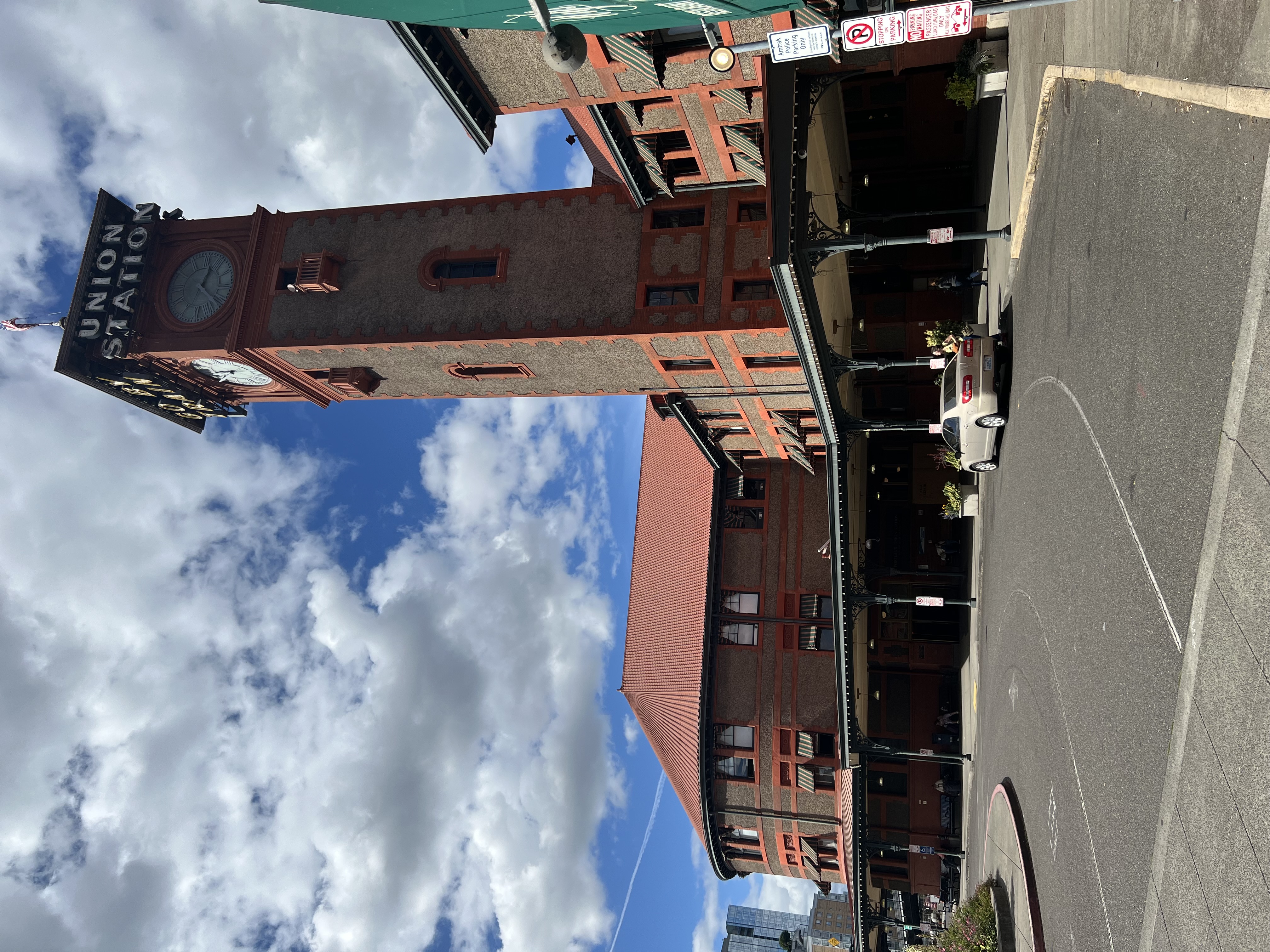
TEXT: Union Station was dedicated in the mid-1890s [1896], as a “unified” station to serve the Northern Pacific, the Union Pacific, and the Southern Pacific Railways. It was built in the Italian Renaissance style, in a graceful curve that faced downtown. It was said by some to be the finest rail station in the West when it was built, and was constructed in an elegant blend of brick, stucco and sandstone. The total project cost $400,000410 [some $11.5 million in today’s dollars].
Central to the station design was the 150-foot clock tower, which was later modified to include the neon "Go By Train" signs that are a familiar Portland icon today. The last major renovation occurred shortly before the Depression [1928].
Being close to the Willamette River, flooding has occasionally been a concern. In the late Forties [1948], a major flood did reach the station, although sandbagging efforts saved it. However, it’s reported that Portland’s Union Station has the only railway station in the country where a sturgeon was caught.
During our typically lengthy stop in Portland, you’re welcome to step off [bring your ticket with you] and visit the historic and beautifully restored Union Station, which was built in the 1890s [1896]. Make sure you bring your ticket with you and pay careful attention to the all-aboard call from the conductor. At a minimum, be back on the train five minutes prior to scheduled departure.
This concludes our Seattle to Portland narration. We hope you have enjoyed learning a little about the towns, mountains, and countryside of Washington and Oregon. On behalf of the National Park Service’s Trails & Rails Program and Amtrak, we wish you a pleasant journey as you complete your trip on the Coast Starlight.
↑ back to top
TEXT: Oregon is home to multiple National Parks, National Monuments, and National Trails – we’d recommend you visit on future trips. Do you enjoy scenery? Exploration? Westward expansion? Geology? Commerce? Native American history? We’ve got it covered.
Can you believe a picturesque lake is actually the center of an incredibly deep volcano? Crater Lake National Park recounts how a cataclysmic eruption triggered the collapse of a tall peak, leaving the deepest lake in our country. It’s scenic; it’s geological; it’s historical; and it’s well worth your time to journey to Crater Lake in Southeastern Oregon.
Are you fascinated by how glaciers had a lasting impact on this area, even though some of them were located in Montana? The Ice Age Floods National Geologic Trail details how cataclysmic floods occurred in the Pacific Northwest between 12,000 and 17,000 years ago, “leaving a lasting mark of dramatic and distinguishing features on the landscape of parts of the States of Montana, Idaho, Washington and Oregon.”
Are you interested in learning more about our country’s first extensive exploration? The Lewis & Clark National Historic Trail stretches from Pittsburgh, Pennsylvania to the mouth of the Columbia River outside of Astoria, Oregon. Preparations were made in Pittsburgh for the groundbreaking expedition and the trail follows the outbound and inbound routes through 16 states. You can also visit nearby Lewis & Clark National Historical Park with its sites stretching from Long Beach, Washington in the north to Canon Beach in the south. A must-see attraction to our northwest, located outside of Astoria, is the re-creation of Fort Clatsop where the Corps of Discovery wintered in 1805 and 1806.
Do you enjoy geology and caves? Tour the inside of caves and their dark, twisting passages of marble rock at Oregon Caves National Monument and Preserve at Cave Junction in the Siskiyou Mountains of southern Oregon.
Do you have an appreciation for natural history? If so, visit the colorful rock formations of the John Day Fossil Beds National Monument that preserve a record of plant and animal evolution, changing climate, and past ecosystems spanning 40 million years. It’s in Kimberly, Oregon about a four-hour drive east of Portland.
Might you be interested in learning about how an arguably misnamed fort was a central trading post for trappers, Native Americans, and early settlers? Fort Vancouver National Historic Site on the north side of the Columbia River is the closest National Park site to us and is located in Vancouver, Washington. Would you believe citizens from about a dozen and a half countries lived and worked at or near the Hudson’s Bay Company fur trading post nearly 200 years ago? A highlight is that from October through February, the Park Service offers twice monthly nighttime tours where guests only have the light from their lanterns to illuminate their way through the trading center’s buildings. Live reenactors present the rich history of the park (it’s similar to reenactments at Colonial Williamsburg, Virginia). Fort Vancouver is one of two sites visitors regularly see the Union Jack fly in the Pacific Northwest on government properties (the other site being San Juan Island National Historical Park).
Interested in learning more about the Nez Perce Native Americans? Nez Perce National Historical Park has a series of sites in the Pacific Northwest that commemorate the contributions of the Nez Perce people to the tapestry of our land. It can be visited at various sites in Oregon, Washington, Idaho, and Montana.
The story of westward expansion into the Pacific Northwest is presented along the Oregon National Historical Trail. The trail is dedicated to preserving the story of migration in the 1800s that greatly expanded the population of the Pacific Northwest. It can be viewed at various sites to our east stretching from Missouri, though Kansas, Nebraska, Wyoming, Idaho, Oregon, and Washington.
Are you fascinated by the California Gold Rush? The California National Historic Trail was the largest “mass migration” of Americans into the west in the 1840s and 1850s in search of gold and a better life. The trail extends through ten states and reaches as far north as Oregon’s Willamette.
↑ back to top